IMAGES TAKEN NEAR TO
Kirknewton, WOOLER, NE71 6TR
Introduction
This page details the photographs taken nearby to NE71 6TR by members of the Geograph project.
The Geograph project started in 2005 with the aim of publishing, organising and preserving representative images for every square kilometre of Great Britain, Ireland and the Isle of Man.

There are currently over 7.5m images from over14,400 individuals and you can help contribute to the project by visiting https://www.geograph.org.uk
Image Map
Images are licensed for reuse under creativecommons.org/licenses/by-sa/2.0
Notes
- Clicking on the map will re-center to the selected point.
- The higher the marker number, the further away the image location is from the centre of the postcode.
Image Listing (32 Images Found)
Images are licensed for reuse under creativecommons.org/licenses/by-sa/2.0
Image
Details
Distance
1
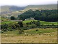
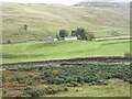
Southernknowe, College Valley
Now a holiday cottage, the former small school close to the confluence of the Lambden and College burns, served many generations of valley children. It began life in 1854 and after some periods of closure re-opened in 1911, and was finally closed in 1968. Pupil numbers varied from just three or four, to a peak of 16 in 1960. All ages of children were taught together by one teacher who lived in the little cottage at Coldburn just along the road Image
http://www.college-valley.co.uk/history.htm
Image: © Andrew Curtis
Taken: 7 Sep 2012
0.00 miles
3
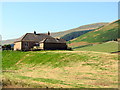
Southernknowe
Cottage and former school at Southernknowe below Cheviot.
Image: © Andrew Curtis
Taken: 25 Jul 2014
0.03 miles
4
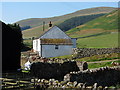
Former school at Southernknowe
The small school with its unique setting, close to the confluence of the Lambden and College Burns, served generations of valley children in the days before widespread mechanisation.
It began life in 1854 and after some periods of closure re-opened in 1911 and finally closed in 1968. Over the years pupil numbers varied from just three or four to sixteen in 1960; all ages of children were taught together by one teacher who lived in the little cottage at Coldburn just along the road.
For many years the school was just one room at the eastern end of Southernknowe farmhouse, the shepherd and his family living at the other side of the party wall. It was entered by a wooden porch where the children left their boots and coats.
When a new bungalow was built for the shepherd in 1939 the school was extended into the farmhouse to include a kitchen cum dining room.
Although remote by comparison to other rural village schools it was within walking distance of all the homes at the top of the valley though nowadays such journeys wouldn't be contemplated for young children who had to contend with the terrain and often inclement weather. During heavy snow some children from more outlying homes would miss school for several weeks.
It is now a holiday cottage Image
http://college-valley.co.uk/history.htm
Image: © Andrew Curtis
Taken: 25 Jul 2014
0.03 miles
5
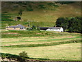
Southernknowe Farm
Near the confluence of the Lambden and College Valleys.
Image: © Oliver Dixon
Taken: 21 Oct 2020
0.03 miles
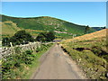
6
Southernknowe Farm
At the start of the private road up the Lambden Burn on the College Valley estate.
Image: © Oliver Dixon
Taken: 29 Apr 2022
0.04 miles
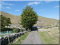
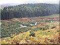
7
Road near Southernknowe
The footpath heading off on the right goes over the hills to Commonburn House Image
The hill behind is the northern spur of Blackhaggs Rigg which is crowned by a hill-fort Image
Image: © Andrew Curtis
Taken: 25 Jul 2014
0.11 miles
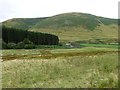
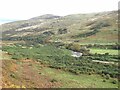
10
Confluence of the Lambden Burn with the College Burn
Short reaches of the Lambden Burn (to the left) and College Burn are visible just above their confluence.
Image: © Oliver Dixon
Taken: 21 Oct 2020
0.13 miles