Former school at Southernknowe
Introduction
The photograph on this page of Former school at Southernknowe by Andrew Curtis as part of the Geograph project.
The Geograph project started in 2005 with the aim of publishing, organising and preserving representative images for every square kilometre of Great Britain, Ireland and the Isle of Man.

There are currently over 7.5m images from over 14,400 individuals and you can help contribute to the project by visiting https://www.geograph.org.uk
Former school at Southernknowe
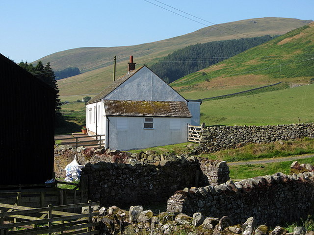
Image: © Andrew Curtis Taken: 25 Jul 2014
The small school with its unique setting, close to the confluence of the Lambden and College Burns, served generations of valley children in the days before widespread mechanisation. It began life in 1854 and after some periods of closure re-opened in 1911 and finally closed in 1968. Over the years pupil numbers varied from just three or four to sixteen in 1960; all ages of children were taught together by one teacher who lived in the little cottage at Coldburn just along the road. For many years the school was just one room at the eastern end of Southernknowe farmhouse, the shepherd and his family living at the other side of the party wall. It was entered by a wooden porch where the children left their boots and coats. When a new bungalow was built for the shepherd in 1939 the school was extended into the farmhouse to include a kitchen cum dining room. Although remote by comparison to other rural village schools it was within walking distance of all the homes at the top of the valley though nowadays such journeys wouldn't be contemplated for young children who had to contend with the terrain and often inclement weather. During heavy snow some children from more outlying homes would miss school for several weeks. It is now a holiday cottage Image http://college-valley.co.uk/history.htm
Images are licensed for reuse under creativecommons.org/licenses/by-sa/2.0
Image Location
Latitude
55.51458
Longitude
-2.177647