IMAGES TAKEN NEAR TO
Akeld, WOOLER, NE71 6TA
Introduction
This page details the photographs taken nearby to NE71 6TA by members of the Geograph project.
The Geograph project started in 2005 with the aim of publishing, organising and preserving representative images for every square kilometre of Great Britain, Ireland and the Isle of Man.

There are currently over 7.5m images from over14,400 individuals and you can help contribute to the project by visiting https://www.geograph.org.uk
Image Map
Images are licensed for reuse under creativecommons.org/licenses/by-sa/2.0
Notes
- Clicking on the map will re-center to the selected point.
- The higher the marker number, the further away the image location is from the centre of the postcode.
Image Listing (37 Images Found)
Images are licensed for reuse under creativecommons.org/licenses/by-sa/2.0
Image
Details
Distance
1
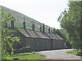
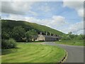
Farm cottages, Akeld
What appears from the road to be a single row of cottages is in fact but one side of a square, as evident from aerial photographs and as described in this link: http://www.northumberlandnationalpark.org.uk/understanding/historyarchaeology/historicvillageatlas/villageatlasakeld/akeldhistory/akeldremodellingthevillage
Image: © Stephen Craven
Taken: 2 Jul 2009
0.01 miles
2
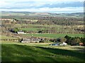
Akeld viewed from the track to Gleadscleugh
The A697 heads north. The B6351 heads west past the eight cottages making up The Square, Akeld.
Image: © Russel Wills
Taken: 18 Nov 2020
0.02 miles
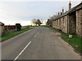
3
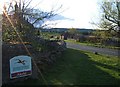
National Park Sign, Akeld
Easter Sunday in the village of Akeld, looking westerly along the B6351.
Image: © Barbara Carr
Taken: 12 Apr 2009
0.02 miles
5
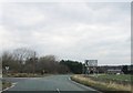
The junction of the B6351 with the A697 at Akeld
Looking eastward.
Image: © Peter Wood
Taken: 8 Dec 2018
0.02 miles
6
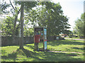
Payphone and post box at Akeld
Although this is a very small community it retains its own post box and phone box.
Image: © Stephen Craven
Taken: 2 Jul 2009
0.03 miles
7
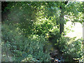
Akeld Burn
This is at the point where the burn ceases to be a hill stream and starts a brief (550m) run across the level land of Glendale.
Image: © Stephen Craven
Taken: 2 Jul 2009
0.03 miles
8
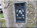
Ordnance Survey Flush Bracket 11268
This bracket can be found on the wall of a cottage at Akeld. The benchmark height is recorded as being 53.279 metres above sea level.
For more detail see : https://www.bench-marks.org.uk/bm11087
Image: © Peter Wood
Taken: 8 Dec 2018
0.03 miles