IMAGES TAKEN NEAR TO
West Street, BELFORD, NE70 7QD
Introduction
This page details the photographs taken nearby to West Street, NE70 7QD by members of the Geograph project.
The Geograph project started in 2005 with the aim of publishing, organising and preserving representative images for every square kilometre of Great Britain, Ireland and the Isle of Man.

There are currently over 7.5m images from over14,400 individuals and you can help contribute to the project by visiting https://www.geograph.org.uk
Image Map (129 Images)


Getting Data...Please wait
Leaflet Map data © OpenStreetMap
Images are licensed for reuse under creativecommons.org/licenses/by-sa/2.0
Notes
- Clicking on the map will re-center to the selected point.
- The higher the marker number, the further away the image location is from the centre of the postcode.
Image Listing (129 Images Found)
Images are licensed for reuse under creativecommons.org/licenses/by-sa/2.0
Image
Details
Distance
4
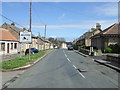
West Street
Looking along the B6349 as it enters Belford.
Image: © DS Pugh
Taken: 26 Jun 2022
0.03 miles
5
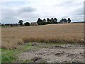
A view of Belford across a corn field
The western outskirts of Belford seen from St Oswald's Way.
Image: © Oliver Dixon
Taken: 15 Aug 2010
0.04 miles
6
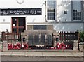
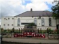
Belford War Memorial
Belford War Memorial, situated next to the road in front of the community club on West Street. Also visible is the community club signage boasting a games room and function room. Through the large window next to the sign it is possible to make out an upper floor inserted part way up the glazing hinting that the building has been converted from a former use, possibly religious. A more extensive view of the community club can be seen in Image
Image: © Graham Robson
Taken: 23 May 2012
0.07 miles
8
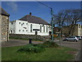
St Mary's Church of England Middle School, Belford
St Mary's Church of England Middle School is attended by pupils from the village and surrounding area. It was formerly called (in the days I attended) Belford County Middle School, but now has an association with St Mary's Church in the village, from which it now takes its name.
Image: © Graham Robson
Taken: 2 Apr 2013
0.07 miles
9
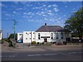
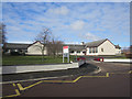
Belford Community Club
Belford Community club seen from the other side of West Street. The village war memorial is situated in the wall in front of the car park. A close up of the war memorial can be seen in Image
Image: © Graham Robson
Taken: 23 May 2012
0.07 miles
10
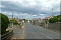
War Memorial and Belford Community Hall. West Street
West Street is the B6349 coming in from the west
Image: © Martin Dawes
Taken: 6 Jul 2020
0.07 miles