IMAGES TAKEN NEAR TO
BELFORD, NE70 7HB
Introduction
This page details the photographs taken nearby to NE70 7HB by members of the Geograph project.
The Geograph project started in 2005 with the aim of publishing, organising and preserving representative images for every square kilometre of Great Britain, Ireland and the Isle of Man.

There are currently over 7.5m images from over14,400 individuals and you can help contribute to the project by visiting https://www.geograph.org.uk
Image Map
Images are licensed for reuse under creativecommons.org/licenses/by-sa/2.0
Notes
- Clicking on the map will re-center to the selected point.
- The higher the marker number, the further away the image location is from the centre of the postcode.
Image Listing (15 Images Found)
Images are licensed for reuse under creativecommons.org/licenses/by-sa/2.0
Image
Details
Distance
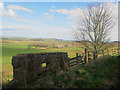
2
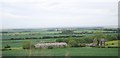
Working the farm
Collecting straw at Chesters.
Image: © DS Pugh
Taken: 12 Aug 2013
0.03 miles
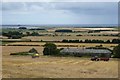
3
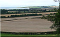
Chesters
A farm with a fantastic view across to Holy Island and the North Sea.
Image: © DS Pugh
Taken: 12 Aug 2013
0.03 miles
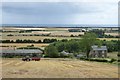
4
The lane to Chesters, near Belford
Looking down private farm lane leading to the houses at Chesters. The entire row of terraced houses on the left is boarded up. A large number of trees have been planted on the margin between the field on the right and the lane.
Image: © Graham Robson
Taken: 24 Apr 2013
0.09 miles
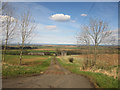
5
Chesters
Looking towards the farm near Middleton.
Image: © DS Pugh
Taken: 12 Aug 2013
0.09 miles
6
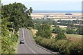
Old Great North Road, north of Belford
The old Great North Road rises from the coastal plain up the hills formed by the igneous intrusive rocks which also form the Farne Islands and the foundation of Bamburgh Castle.
Image: © Richard Kay
Taken: 12 Aug 2009
0.11 miles
7
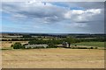
Farmland near Belford (2)
Flat farmland by the sea.
Picked out by the sun is Budle Bay, culminating at Budle Point.
Concealed within this placid scene are the A1 (in the trees behind the telegraph pole), and beyond that the Newcastle-Edinburgh railway line (you may just be able to make out some overhead power lines).
Image: © Stephen Richards
Taken: Unknown
0.13 miles
8
Embankment by Craigmill Quarry
There is a large embankment alongside the old A1 north of Belford. The embankment extends well beyond the current quarry area.
Image: © Richard Webb
Taken: 9 Aug 2011
0.16 miles
9
Remnant of a Pillbox, North Bank, near Middleton
The partial remains of a Second World War pillbox sit on the edge of North Bank, near Middleton. The buildings at Chesters can be seen in background.
Image: © Graham Robson
Taken: 24 Apr 2013
0.19 miles
10
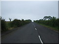
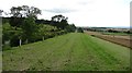
Minor road towards Belford, Chapel Hill
National Cycle Route 1.
Image: © JThomas
Taken: 6 Jul 2012
0.20 miles