IMAGES TAKEN NEAR TO
Crag View Gardens, ALNWICK, NE66 2QQ
Introduction
This page details the photographs taken nearby to Crag View Gardens, NE66 2QQ by members of the Geograph project.
The Geograph project started in 2005 with the aim of publishing, organising and preserving representative images for every square kilometre of Great Britain, Ireland and the Isle of Man.

There are currently over 7.5m images from over14,400 individuals and you can help contribute to the project by visiting https://www.geograph.org.uk
Image Map (Loading...)


Getting Data...Please wait
Leaflet Map data © OpenStreetMap
Images are licensed for reuse under creativecommons.org/licenses/by-sa/2.0
Notes
- Clicking on the map will re-center to the selected point.
- The higher the marker number, the further away the image location is from the centre of the postcode.
Image Listing (57 Images Found)
Images are licensed for reuse under creativecommons.org/licenses/by-sa/2.0
Image
Details
Distance
1

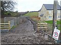
'Alternative Footpath'
The building construction work has blocked the 'official' footpath and sent pedestrians through this mud-bath path.
Image: © Russel Wills
Taken: 1 Mar 2020
0.03 miles
2
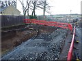
The public bridleway has been dug up for new houses
The alternative route is now this quagmire.
Image: © Russel Wills
Taken: 26 Dec 2020
0.03 miles
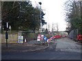
3
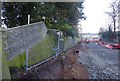
Road widening!
Disconcerting if you live in the house on the left!
Traffic levels will rise when 200+ houses are built down there.
Image: © Russel Wills
Taken: 8 Dec 2019
0.03 miles
4
Public bridleway now firmly closed!
The local residents are not happy that their single track bridleway is being converted to a two-way road to access a housing estate with more than 200 houses.
Image: © Russel Wills
Taken: 8 Dec 2019
0.03 miles
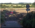
5
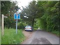
Start of bridleway
The bridleway starts here at Alnmouth Road and runs to Lough House where it becomes a footpath.
Image: © Michael Dibb
Taken: 23 May 2011
0.04 miles
6
Roadworks to widen the access lane to a new estate road
Completely blocking a favourite walk down to the River Aln.
Image: © Russel Wills
Taken: 8 Dec 2019
0.04 miles
7
Public bridleway has been dug up!
Our gentle stroll to the river bank along the public bridleway is disrupted.
A sign says 'Public Bridleway will be closed for a period of 6 months.
There is no alternative route available'.
Image: © Russel Wills
Taken: 7 Sep 2019
0.04 miles
8

Putting in new services in Alnmouth Road, Alnwick
To supply gas and water to new developments at Peter's Mill.
Image: © Russel Wills
Taken: 29 Apr 2020
0.04 miles
9
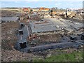
House foundations at Peter?s Mill
Looking towards the Sewage Works.
Image: © Russel Wills
Taken: 1 Mar 2020
0.04 miles
10
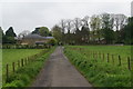
The eastern edge of Alnwick
Seen on the track from Lough House.
Image: © Bill Boaden
Taken: 20 May 2013
0.05 miles