IMAGES TAKEN NEAR TO
Eglingham, ALNWICK, NE66 2DT
Introduction
This page details the photographs taken nearby to NE66 2DT by members of the Geograph project.
The Geograph project started in 2005 with the aim of publishing, organising and preserving representative images for every square kilometre of Great Britain, Ireland and the Isle of Man.

There are currently over 7.5m images from over14,400 individuals and you can help contribute to the project by visiting https://www.geograph.org.uk
Image Map
Images are licensed for reuse under creativecommons.org/licenses/by-sa/2.0
Notes
- Clicking on the map will re-center to the selected point.
- The higher the marker number, the further away the image location is from the centre of the postcode.
Image Listing (24 Images Found)
Images are licensed for reuse under creativecommons.org/licenses/by-sa/2.0
Image
Details
Distance
1
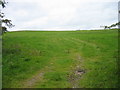
House at top of field
The house at Tarry seen from the byway climbing towards it.
Russel Wills has a similar image: in his description he tells that the name comes from a type of coal that once was mined there, having a high tar content - https://www.geograph.org.uk/photo/3282438 .
Image: © Trevor Littlewood
Taken: 8 Mar 2023
0.01 miles
2
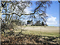
Track to Tarry
Coal used to be mined here. There is still a shaft at Tarry, which derived its name from the coal which contained 60-65% tar. There is now only one house at Tarry where there used to be about a dozen.
Image: © Russel Wills
Taken: 5 Jan 2013
0.01 miles
3
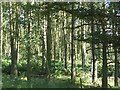
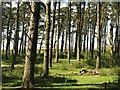
Pine wood, Eglingham Moor
The woodland on the east side of the road, by Tarry contrasts with the wood to the west by being enclosed and having a fern ground story.
Image: © Richard Webb
Taken: 2 Jul 2009
0.05 miles
4
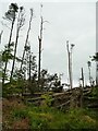
Fallen trees in Tarry Wood (2)
Victims of Storm Arwen in November 2021. So many trees were lost in Northumberland in that storm that many had not been dealt with eight months later.
Image: © Stephen Craven
Taken: 23 Jul 2022
0.05 miles
6
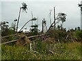
Fallen trees in Tarry Wood (1)
Victims of Storm Arwen in November 2021. So many trees were lost in Northumberland in that storm that many had not been dealt with eight months later.
Image: © Stephen Craven
Taken: 23 Jul 2022
0.09 miles
7
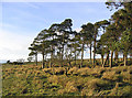
Pine wood, Eglingham Moor
A small wood, open for grazing.
Image: © Richard Webb
Taken: 2 Jul 2009
0.10 miles
8
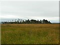
Tarry Woods, Eglingham Moor
Even from this distance you can see the damage caused by Storm Arwen in November 2021.
Image: © Stephen Craven
Taken: 23 Jul 2022
0.10 miles
9
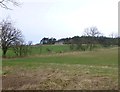
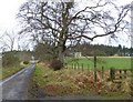
Looking across the fields from the bridleway
Towards Tarry, named after the tarry coal produced locally.
Image: © Russel Wills
Taken: 5 Jan 2013
0.17 miles