IMAGES TAKEN NEAR TO
Clayport Street, ALNWICK, NE66 1LF
Introduction
This page details the photographs taken nearby to Clayport Street, NE66 1LF by members of the Geograph project.
The Geograph project started in 2005 with the aim of publishing, organising and preserving representative images for every square kilometre of Great Britain, Ireland and the Isle of Man.

There are currently over 7.5m images from over14,400 individuals and you can help contribute to the project by visiting https://www.geograph.org.uk
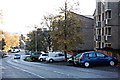
Image Map
Images are licensed for reuse under creativecommons.org/licenses/by-sa/2.0
Notes
- Clicking on the map will re-center to the selected point.
- The higher the marker number, the further away the image location is from the centre of the postcode.
Image Listing (339 Images Found)
Images are licensed for reuse under creativecommons.org/licenses/by-sa/2.0
Image
Details
Distance
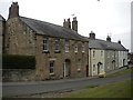
1
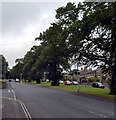
Road into Alnwick
The B6341 from Rothbury.
Image: © Trevor Harris
Taken: 26 Oct 2011
0.02 miles
2
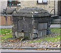
Clayport Pant
On the south side of Clayport, outside Westgate House.
It is in the form of a large, squat pillar in local sandstone. There is an iron spout on the north side, with an inscribed panel above it, and the remains of a broken trough below. On the east side there are signs of repair, and remains of a metal bracket. On the west side there is a Wooden door fixed with screwed bars.
The date at 1755 makes it the oldest pant in Alnwick. (St Michael's Pant dates from 1759).
Image: © Russel Wills
Taken: 30 Sep 2013
0.02 miles
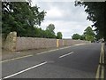
3
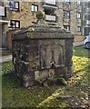
Clayport Pant
Ball has been replaced. Still no water.
Can't imagine it won many prizes for architecture.
For more information see
Image
Image: © Leanmeanmo
Taken: 2 Mar 2020
0.02 miles
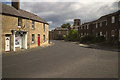
4
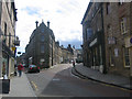
Alnwick Street Scene
Standing on Narrowgate we see Fenkle Street forking off to the right.
Image: © Ron Goodhew
Taken: 6 May 2005
0.03 miles
5
Clive Terrace, Alnwick
Parallel to Clayport Street (behind the photographer).
Image: © Richard Vince
Taken: 29 Jun 2018
0.04 miles
6
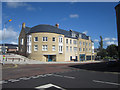
New residential and retail development, Alnwick
This new development in Alnwick town centre includes retail space on the ground floor (much of it still unlet 12 months after the buildings completion) and a large number of flats on the upper floors.
Image: © Graham Robson
Taken: 28 Aug 2012
0.05 miles
8
New retail and residential development, Alnwick
A recently completed development in the centre of Alnwick containing shops on the ground floor (mostly still unlet) and residential flats on the upper floors. The shops currently open in the development are Store 21 and Wilkinson.
Image: © Graham Robson
Taken: 28 Aug 2012
0.07 miles
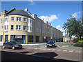
10
Site of former bus depot, Lisburn Street, Alnwick
The site of the former Arriva (and its various predecessors) bus depot in Alnwick. The large bus shed has been demolished and is awaiting a new development.
Image: © Graham Robson
Taken: 11 Jul 2015
0.07 miles