IMAGES TAKEN NEAR TO
Waverdale Avenue, NEWCASTLE UPON TYNE, NE6 4UN
Introduction
This page details the photographs taken nearby to Waverdale Avenue, NE6 4UN by members of the Geograph project.
The Geograph project started in 2005 with the aim of publishing, organising and preserving representative images for every square kilometre of Great Britain, Ireland and the Isle of Man.

There are currently over 7.5m images from over14,400 individuals and you can help contribute to the project by visiting https://www.geograph.org.uk
Image Map
Images are licensed for reuse under creativecommons.org/licenses/by-sa/2.0
Notes
- Clicking on the map will re-center to the selected point.
- The higher the marker number, the further away the image location is from the centre of the postcode.
Image Listing (19 Images Found)
Images are licensed for reuse under creativecommons.org/licenses/by-sa/2.0
Image
Details
Distance
1
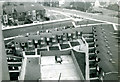
Tumulus and Philiphaugh from Walkerdene House
Aerial view taken from 14th Floor of Walkerdene House 1974. Pete Watsons shop visible at top of photograph. Demolition of the end of Philiphaugh just recent and road closed.
Image: © Wayne Phillips
Taken: 1 Oct 1974
0.14 miles
5
Entering Newcastle on the Hadrian's Wall path
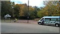
On this day the marshalls were looking out for runners and riders on the combined marathon, half marathon and cycle rides from Morpeth via Whitley Bay to Newcastle. The M2N, C2N and N2N events
This 'runner' seemed to take so many pictures he was almost last! But first aid wasn't needed.
Image: © Chris Morgan
Taken: 30 Oct 2016
0.19 miles
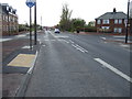
6
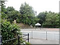
Hadrian's Wall Path crosses Neptune Road
Image: © Anthony Parkes
Taken: 29 Jul 2014
0.19 miles
7
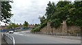
Newcastle's old railway relics III
This sandstone bridge abutment is situated on Neptune Road in Wallsend, and until 1973, carried the North Eastern Railway Riverside Branch.
Image: © Bobby Clegg
Taken: 21 Jun 2014
0.19 miles
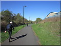
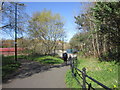
9
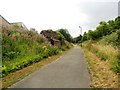
Hadrian's Wall Path in Walker
This is the former River Line Railway, which now forms a very nice walk from Wallsend to Newcastle. At this time of year, in late summer, it's a riot of wild flowers.
Image: © Robert Graham
Taken: 24 Jul 2013
0.21 miles
10

Hadrian's Way crosses Neptune Road, Low Walker
Hadrian's Way is the name given to the traffic-free route along the north bank of the Tyne between the western and eastern boundaries of the City of Newcastle. At its eastern end, the Way follows the course of a disused railway. The Way is followed by both Hadrian's Wall National Trail
http://www.nationaltrail.co.uk/hadrianswall/ and by route 72 of the National Cycle Network (Hadrian's Cycleway
http://www.cycle-routes.org/HADRIANSCYCLEWAY/ and the Tynemouth branch of the C2C Cycle Route http://www.c2c-guide.co.uk/ ); although just at this point, where a bridge over the road is missing, the cycleway takes a more circuitous route to avoid the steep drop to the road.
Image: © Oliver Dixon
Taken: 18 Nov 2008
0.21 miles