IMAGES TAKEN NEAR TO
St. Michaels Road, NEWCASTLE UPON TYNE, NE6 1QU
Introduction
This page details the photographs taken nearby to St. Michaels Road, NE6 1QU by members of the Geograph project.
The Geograph project started in 2005 with the aim of publishing, organising and preserving representative images for every square kilometre of Great Britain, Ireland and the Isle of Man.

There are currently over 7.5m images from over14,400 individuals and you can help contribute to the project by visiting https://www.geograph.org.uk
Image Map
Images are licensed for reuse under creativecommons.org/licenses/by-sa/2.0
Notes
- Clicking on the map will re-center to the selected point.
- The higher the marker number, the further away the image location is from the centre of the postcode.
Image Listing (248 Images Found)
Images are licensed for reuse under creativecommons.org/licenses/by-sa/2.0
Image
Details
Distance
1
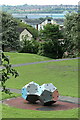
Climbing frame, St Lawrence Park
Below are two dodecahedredron pieces designed as a climbing wall probably the same as these from Sweden https://commons.wikimedia.org/wiki/File:Dodecahedron_climbing_wall.jpg
Image: © Andrew Curtis
Taken: 3 Jun 2021
0.06 miles
2
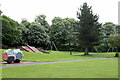
St Lawrence Park, Byker
St Lawrence Park is a small neighbourhood park on the site of a former clay pit and brickworks. It was developed as a recreation area in the Byker estate in the late 19th/early 20th century.
The popular park has a play area, open grassland for informal recreation and ball games and a network of footpaths.
Image: © Andrew Curtis
Taken: 3 Jun 2021
0.07 miles
4
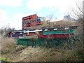
Pigeon lofts by the old railway
The pigeon lofts seem to mimic the style of the Byker Wall, seen above. Others are shown here Image
Image: © Andrew Curtis
Taken: 28 Mar 2010
0.09 miles
5
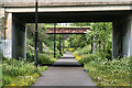
Byker Link
The Byker Link which uses the trackbed of the old Riverside Branch Railway.
Image: © Peter McDermott
Taken: 21 May 2011
0.09 miles
6
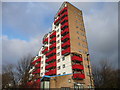
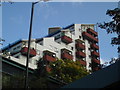
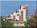
Byker Wall
Part of the Byker Wall at Dunn Terrace in Byker.
Image: © Peter McDermott
Taken: 23 Aug 2008
0.10 miles
7
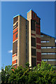
Tom Collins' House
Ralph Erskine (RIP) designed the coolest sheltered housing in the world. This is of course an appendix of the Byker Wall and is one of the most striking and visible buildings on Tyneside.
Image: © MSX
Taken: 16 Oct 2005
0.10 miles
8
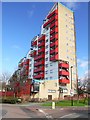
Tom Collins House, Byker Wall
An extravagant sheltered housing block which terminates the south-east end of the north westerly Dunn Terrace sector of Byker Wall
Image: © Andrew Curtis
Taken: 28 Mar 2010
0.10 miles
9
Tom Collins House, Byker
See also Image (photographed by Andrew Curtis).
Image: © Mike Quinn
Taken: 13 Oct 2015
0.11 miles
10
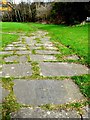
Gravestone pathway, Ballast Hills
Ballast Hills was once a notable landmark created with the dumped ballast of returning colliers. The site later become an important non-conformist burial-ground from C17th until its closure in 1853. Today, the area is a park Image, with some paths created using the graveyard headstones.
Tyne and Wear HER (1597): Ouseburn, Ballast Hills Graveyard http://www.twsitelines.info
Image: © Andrew Curtis
Taken: 28 Mar 2010
0.11 miles