
IMAGES TAKEN NEAR TO
Albion Row, NEWCASTLE UPON TYNE, NE6 1LR
Introduction
This page details the photographs taken nearby to Albion Row, NE6 1LR by members of the Geograph project.
The Geograph project started in 2005 with the aim of publishing, organising and preserving representative images for every square kilometre of Great Britain, Ireland and the Isle of Man.

There are currently over 7.5m images from over14,400 individuals and you can help contribute to the project by visiting https://www.geograph.org.uk
Image Map
Images are licensed for reuse under creativecommons.org/licenses/by-sa/2.0
Notes
- Clicking on the map will re-center to the selected point.
- The higher the marker number, the further away the image location is from the centre of the postcode.
Image Listing (279 Images Found)
Images are licensed for reuse under creativecommons.org/licenses/by-sa/2.0
Image
Details
Distance
1
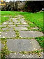
Gravestone pathway, Ballast Hills
Ballast Hills was once a notable landmark created with the dumped ballast of returning colliers. The site later become an important non-conformist burial-ground from C17th until its closure in 1853. Today, the area is a park Image, with some paths created using the graveyard headstones.
Tyne and Wear HER (1597): Ouseburn, Ballast Hills Graveyard http://www.twsitelines.info
Image: © Andrew Curtis
Taken: 28 Mar 2010
0.05 miles
2
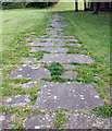
The Gravestone Paths
The path situated at the back of the former Domestos works and close to the Ouseburn School, created in the 1930s. About 200 headstones from the Bellast Hills burial ground (known locally as plaguey fields) were used, dating from the
17th century until 1853.
Image: © peter maddison
Taken: 25 Aug 2010
0.05 miles
3
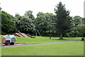
St Lawrence Park, Byker
St Lawrence Park is a small neighbourhood park on the site of a former clay pit and brickworks. It was developed as a recreation area in the Byker estate in the late 19th/early 20th century.
The popular park has a play area, open grassland for informal recreation and ball games and a network of footpaths.
Image: © Andrew Curtis
Taken: 3 Jun 2021
0.05 miles

5
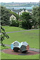
Climbing frame, St Lawrence Park
Below are two dodecahedredron pieces designed as a climbing wall probably the same as these from Sweden https://commons.wikimedia.org/wiki/File:Dodecahedron_climbing_wall.jpg
Image: © Andrew Curtis
Taken: 3 Jun 2021
0.05 miles
6
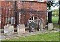
The Gravestone
The gravestones of the non-conformist ministers
Image: © peter maddison
Taken: 25 Aug 2010
0.06 miles
7
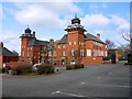
Former Ouseburn Schools, Albion Row
Built by F.W. Rich and characterised by Dutch type gables, decorative moulded brickwork and pagoda style turrets similar to those found on Burmese temples. The schools opened in 1893, closed in the 1960s and the building re-opened in 1993 as a Business Development Centre.
Tyne and Wear HER (5580): Ouseburn, Albion Row, Ouseburn Schools http://www.twsitelines.info
Image: © Andrew Curtis
Taken: 28 Mar 2010
0.07 miles

9
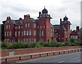
Former Ouseburn Schools, Walker Road, Newcastle
By F.W. Rich, 1891-93. Rich seems to have been rather a flamboyant architect and here this quality manifests itself most forcefully in the fantastic roofs of the towers (Image]). Grade II* listed.
Now the Newcastle Enterprise Centres, offering serviced offices.
Image: © Stephen Richards
Taken: 14 Aug 2012
0.08 miles
10
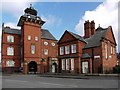
Former Ouseburn Schools & Caretaker's House, Ford Street
The whole school building from Albion Row is shown here Image
Image: © Andrew Curtis
Taken: 28 Mar 2010
0.08 miles