IMAGES TAKEN NEAR TO
Willow Park, MORPETH, NE61 4DA
Introduction
This page details the photographs taken nearby to Willow Park, NE61 4DA by members of the Geograph project.
The Geograph project started in 2005 with the aim of publishing, organising and preserving representative images for every square kilometre of Great Britain, Ireland and the Isle of Man.

There are currently over 7.5m images from over14,400 individuals and you can help contribute to the project by visiting https://www.geograph.org.uk
Image Map
Images are licensed for reuse under creativecommons.org/licenses/by-sa/2.0
Notes
- Clicking on the map will re-center to the selected point.
- The higher the marker number, the further away the image location is from the centre of the postcode.
Image Listing (35 Images Found)
Images are licensed for reuse under creativecommons.org/licenses/by-sa/2.0
Image
Details
Distance
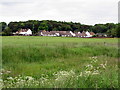
1
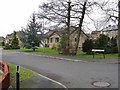
Willow Park, Scots Gap
A little village, including this modern estate, has grown up around the railway junction at Scots Gap.
Image: © Oliver Dixon
Taken: 10 Jan 2012
0.02 miles
2
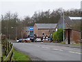
Filling station at Scots Gap
An important cattle mart and small village has grown up at Scots Gap on the site of a disused railway station which was a junction between the "Wannie Line" (Morpeth to Reedsmouth) and a branch line up to Rothbury.
Image: © Oliver Dixon
Taken: 10 Jan 2012
0.05 miles
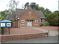
4

Filling station and workshops at Scots Gap
Robson & Cowan have developed a substantial enterprise at Scots Gap serving the needs of the regional agricultural community. This large workshop catering for the repair of large agricultural machinery complements the large sales area on the site of the station goods yard http://www.geograph.org.uk/photo/1549603
Image: © Alan Murray-Rust
Taken: 12 Jun 2013
0.06 miles
6
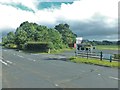
Scot's Gap
Looking across the road junction to the car park by the auction mart.
Image: © Barbara Carr
Taken: 15 Sep 2013
0.08 miles
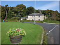
8
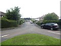
Oakford
Residential cul-de-sac in Scots Gap village.
Image: © Oliver Dixon
Taken: 11 Jul 2020
0.08 miles
9
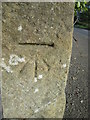
Ordnance Survey Cut Mark
This OS cut mark can be found on the gatepost of the house at the road junction. It marks a point 161.430m above mean sea level.
Image: © Adrian Dust
Taken: 9 Oct 2015
0.08 miles
10
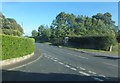
Road to Hartburn and Morpeth
Looking eastward from the road junction at Scot's Gap. (The telephone box is more accurately positioned on the larger-scale map.)
Image: © Barbara Carr
Taken: 15 Sep 2013
0.09 miles