IMAGES TAKEN NEAR TO
Emily Davison Avenue, MORPETH, NE61 2PL
Introduction
This page details the photographs taken nearby to Emily Davison Avenue, NE61 2PL by members of the Geograph project.
The Geograph project started in 2005 with the aim of publishing, organising and preserving representative images for every square kilometre of Great Britain, Ireland and the Isle of Man.

There are currently over 7.5m images from over14,400 individuals and you can help contribute to the project by visiting https://www.geograph.org.uk
Image Map (Loading...)


Getting Data...Please wait
Leaflet Map data © OpenStreetMap
Images are licensed for reuse under creativecommons.org/licenses/by-sa/2.0
Notes
- Clicking on the map will re-center to the selected point.
- The higher the marker number, the further away the image location is from the centre of the postcode.
Image Listing (54 Images Found)
Images are licensed for reuse under creativecommons.org/licenses/by-sa/2.0
Image
Details
Distance
1
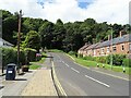
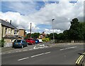
Curly Kews road, Morpeth
This strangely named road runs west from Oldgate Bridge on the west side of the town centre. The road itself seems to be postwar from map evidence, which must be when this area of the town was developed. The terrace on the right however dates from earlier, the beginning of the 20th century.
Image: © Robert Graham
Taken: 10 Jul 2023
0.13 miles
2
Morpeth - west bank of River Wansbeck
Photo taken just south of Oldgate Bridge. Please see Image for an alternative view.
Image: © Dave Bevis
Taken: 28 Apr 2012
0.14 miles
3
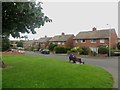
Church Walk, Morpeth
A street lined with semi detached houses to the west of Morpeth town centre.
Image: © Graham Robson
Taken: 3 Jul 2016
0.15 miles
4
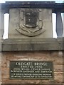
Plaque and crest on Oldgate Bridge
A crest above a plaque on Oldgate Bridge. The bridge was built in 1970 and crosses the River Wansbeck near Morpeth town centre.
Image: © Graham Robson
Taken: 3 Jul 2016
0.15 miles
5
West end of Oldgate Bridge, Morpeth
The road comes over the bridge onto Curly Kews road. The road running along the river in the centre is High Stanners.
Image: © Robert Graham
Taken: 10 Jul 2023
0.16 miles
6
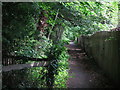
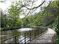
Lady's Walk, Morpeth
This is part of Lady’s Walk, a picturesque footpath route along the bank of the River Wansbeck, connecting Morpeth town centre with the nearby village of Mitford. The name Lady's Walk first appeared on the 1924 edition of the Ordnance Survey Six-Inch map of the area at a point not far from here.
Image: © Geoff Holland
Taken: 10 Aug 2020
0.16 miles
7
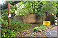
Riverside footpath closed, Morpeth
Our plan to return along the S bank of the Wansbeck was thwarted by a landslip.
Image: © Jim Barton
Taken: 1 Oct 2019
0.17 miles
8
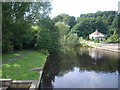
A view down the river from Oldgate Bridge
Image: © Nick Mutton 01329 000000
Taken: 16 Aug 2008
0.17 miles
9
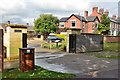
Flood defences, Morpeth
A flood wall and flood gate by the River Wansbeck. In September 2008 1000 homes and businesses were flooded. Subsequently a flood protection scheme was planned and completed in 2015.
Image: © Jim Barton
Taken: 28 Sep 2017
0.17 miles
10
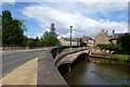
Oldgate Bridge
Located on the River Wansbeck in Carlisle Park.
Image: © DS Pugh
Taken: 4 Jul 2015
0.17 miles