IMAGES TAKEN NEAR TO
Bardon Mill, HEXHAM, NE47 7EZ
Introduction
This page details the photographs taken nearby to NE47 7EZ by members of the Geograph project.
The Geograph project started in 2005 with the aim of publishing, organising and preserving representative images for every square kilometre of Great Britain, Ireland and the Isle of Man.

There are currently over 7.5m images from over14,400 individuals and you can help contribute to the project by visiting https://www.geograph.org.uk
Image Map
Images are licensed for reuse under creativecommons.org/licenses/by-sa/2.0
Notes
- Clicking on the map will re-center to the selected point.
- The higher the marker number, the further away the image location is from the centre of the postcode.
Image Listing (6 Images Found)
Images are licensed for reuse under creativecommons.org/licenses/by-sa/2.0
Image
Details
Distance
2
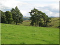
Brown Rigg
View from the unclassified road to the farmstead mapped as Brown Rigg. Far right is another farm, Cranberry Brow.
Image: © Mick Garratt
Taken: 29 Apr 2006
0.17 miles
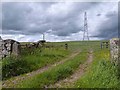
5
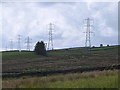
March of the pylons
On the northern slopes of South Tynedale. See also Image
Image: © Oliver Dixon
Taken: 15 Jun 2013
0.23 miles
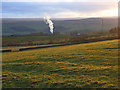
6
Unclassified Road, Ramshawfield
Looking down the road into the South Tyne valley from the industrial buildings occupying the former colliery site at Ramshawfield.
Image: © Mick Garratt
Taken: 29 Apr 2006
0.24 miles