IMAGES TAKEN NEAR TO
Bardon Mill, HEXHAM, NE47 7AH
Introduction
This page details the photographs taken nearby to NE47 7AH by members of the Geograph project.
The Geograph project started in 2005 with the aim of publishing, organising and preserving representative images for every square kilometre of Great Britain, Ireland and the Isle of Man.

There are currently over 7.5m images from over14,400 individuals and you can help contribute to the project by visiting https://www.geograph.org.uk
Image Map
Images are licensed for reuse under creativecommons.org/licenses/by-sa/2.0
Notes
- Clicking on the map will re-center to the selected point.
- The higher the marker number, the further away the image location is from the centre of the postcode.
Image Listing (99 Images Found)
Images are licensed for reuse under creativecommons.org/licenses/by-sa/2.0
Image
Details
Distance

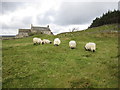
3
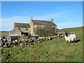
Hotbank
Hotbank is a farmhouse in the shadow of Milecastle 38 of Hadrian's Wall (at least, its location would have been in the shadow when the wall was its original 4.5m height and the milecastle presumably rather bigger). There is a branch path heading past the buildings, but signage attempts to deter walkers from using it on the rather specious grounds of the risk of Coronavirus infection. That path wasn't on our route, so we were not affected but, come on, this is the outdoors, and no-one is going to hang around for fiteen minutes trying to get too close. Public rights of way may have been closed during foot and mouth, but that's a lot more infectious, and even our government haven't yet introduced cull and cremate as a control measure...
Image: © Andy Waddington
Taken: 11 Dec 2020
0.00 miles
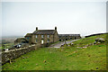
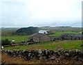
4
Hotbank Farm from Hadrian's Wall Path
Image: © Anthony Parkes
Taken: 20 Sep 2014
0.00 miles
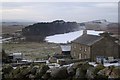
7
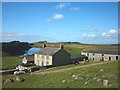
Hotbank and Crag Lough
A typically sturdy Northumbrian farmhouse in an iconic location just north of the line of Hadrian's Wall. Crag Lough, below the shadowed ramparts of Highshield Crags, is owned by the National Trust. Just above the left-hand chimney of the farmhouse is Winshield Crags (345m), the highest point of the Wall.
Image: © Karl and Ali
Taken: 2 Sep 2014
0.01 miles
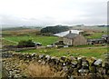
8
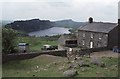
Hotbank Farm
Hotbank Farm with Crag Lough and Highshields Crags in the background. Viewed from the path beside Hadrian's Wall.
Image: © Philip Halling
Taken: 20 Jun 1988
0.01 miles