IMAGES TAKEN NEAR TO
Langley Gardens, HEXHAM, NE47 6EE
Introduction
This page details the photographs taken nearby to Langley Gardens, NE47 6EE by members of the Geograph project.
The Geograph project started in 2005 with the aim of publishing, organising and preserving representative images for every square kilometre of Great Britain, Ireland and the Isle of Man.

There are currently over 7.5m images from over14,400 individuals and you can help contribute to the project by visiting https://www.geograph.org.uk
Image Map
Images are licensed for reuse under creativecommons.org/licenses/by-sa/2.0
Notes
- Clicking on the map will re-center to the selected point.
- The higher the marker number, the further away the image location is from the centre of the postcode.
Image Listing (14 Images Found)
Images are licensed for reuse under creativecommons.org/licenses/by-sa/2.0
Image
Details
Distance
1
Innerhaugh Mews
Modern housing estate on the western side of Haydon Bridge. The road to the right was the course of the A69 until the recent construction of the by-pass round the village.
Image: © Oliver Dixon
Taken: 2 Sep 2015
0.07 miles
2
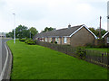
Greenwich Gardens
Bungalows on the west side of Haydon Bridge.
Image: © Oliver Dixon
Taken: 2 Sep 2015
0.09 miles
3
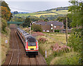
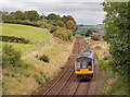
VTEC diversions - 16 September 2017 (6)
Virgin Trains East Coast HST 43311 pulls away from Haydon Bridge station with the diverted 10.00 passenger service from King's Cross to Inverness.
Image: © The Carlisle Kid
Taken: 16 Sep 2017
0.12 miles
4
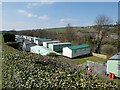
Poplars Riverside Caravan Park
Beside the River South Tyne on the edge of Haydon Bridge village.
Image: © Oliver Dixon
Taken: 19 Apr 2021
0.16 miles
5
142068 leaving Haydon Bridge - September 2017
Diesel unit 142068 pulls away from Haydon Bridge station with the 12.23 passenger service from Newcastle to Carlisle.
Image: © The Carlisle Kid
Taken: 16 Sep 2017
0.17 miles
6
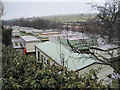
Poplars Riverside Caravan Park, Haydon Bridge
Image: © Les Hull
Taken: 24 Feb 2010
0.17 miles
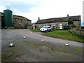
7
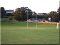
Haydon Bridge Community High School - playing fields and farm
The farm is linked with the school to teach agriculture to GCSE and BTEC students. A public footpath runs up the hill behind the wall.
Image: © Marcus Byron
Taken: 30 Sep 2007
0.17 miles
9
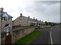
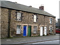
East Land Ends
The cottage at the left hand end of the block is the birthplace of the Norhumbrian artist John Martin.
Image: © Oliver Dixon
Taken: 14 Apr 2008
0.21 miles
10
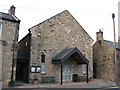
Haydon Bridge Community Centre
Formerly a Wesleyan Chapel.
Image: © Mike Quinn
Taken: 2 Nov 2007
0.21 miles