IMAGES TAKEN NEAR TO
Painshawfield Road, STOCKSFIELD, NE43 7PX
Introduction
This page details the photographs taken nearby to Painshawfield Road, NE43 7PX by members of the Geograph project.
The Geograph project started in 2005 with the aim of publishing, organising and preserving representative images for every square kilometre of Great Britain, Ireland and the Isle of Man.

There are currently over 7.5m images from over14,400 individuals and you can help contribute to the project by visiting https://www.geograph.org.uk
Image Map
Images are licensed for reuse under creativecommons.org/licenses/by-sa/2.0
Notes
- Clicking on the map will re-center to the selected point.
- The higher the marker number, the further away the image location is from the centre of the postcode.
Image Listing (17 Images Found)
Images are licensed for reuse under creativecommons.org/licenses/by-sa/2.0
Image
Details
Distance
1
Cade Hill Road
An illustration that this residential area is very leafy.
Image: © Bill Boaden
Taken: 21 Apr 2017
0.10 miles
2
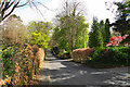
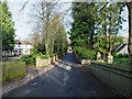
Painshawfield Road
This is the western end of Painshawfield Road, viewed looking east; it's a residential road in the Painshawfield or Park Estate area of the commuter village of Stocksfield. Properties there are mainly large, detached and set in good-sized gardens.
Image: © Trevor Littlewood
Taken: 11 Feb 2019
0.14 miles
3
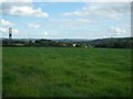
Looking towards Stocksfield from Wheelbirks Farm
Looking across farmland towards Stocksfield
Image: © Kevin Hall
Taken: 4 Sep 2011
0.14 miles
4
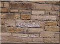
Choc and Dan carved in stone
A long new wall has been built which looks magnificent, I assume Choc and Dan were the constructors of the wall?
Image: © chris whitehouse
Taken: 10 Jul 2013
0.17 miles
5
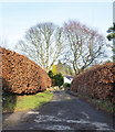
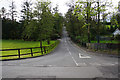
Cadehill Road
Cadehill Road is part of Painshawfield or Park Estate which accounts for much of the housing stock in the commuter village of Stocksfield. Properties there are generally large, detached and are surrounded by substantial gardens.
Image: © Trevor Littlewood
Taken: 11 Feb 2019
0.18 miles
6
Apperley Road, Painshawfield
There are still gradients in this residential area below Mickley Common.
Image: © Bill Boaden
Taken: 21 Apr 2017
0.19 miles
7
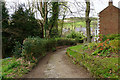
Path to Ridley Mill
There is a cluster of dwellings in the valley bottom by Stocksfield Burn.
Image: © Bill Boaden
Taken: 21 Apr 2017
0.19 miles
8
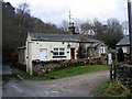
Rose Cottage near Ridley Mill, Stocksfield
Image: © Brian Norman
Taken: 16 Mar 2008
0.21 miles
9
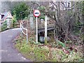
Bridge over the Stocksfield Burn
Leading to a few houses on the right bank of the burn. A footpath continues up to Painshawfield.
Image: © Oliver Dixon
Taken: 30 Dec 2019
0.21 miles
10
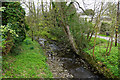
Stocksfield Burn
Passing Ridley Mill on its way to meet the River Tyne.
Image: © Bill Boaden
Taken: 21 Apr 2017
0.21 miles