IMAGES TAKEN NEAR TO
Rowan Grove, PRUDHOE, NE42 6PP
Introduction
This page details the photographs taken nearby to Rowan Grove, NE42 6PP by members of the Geograph project.
The Geograph project started in 2005 with the aim of publishing, organising and preserving representative images for every square kilometre of Great Britain, Ireland and the Isle of Man.

There are currently over 7.5m images from over14,400 individuals and you can help contribute to the project by visiting https://www.geograph.org.uk
Image Map (Loading...)


Getting Data...Please wait
Leaflet Map data © OpenStreetMap
Images are licensed for reuse under creativecommons.org/licenses/by-sa/2.0
Notes
- Clicking on the map will re-center to the selected point.
- The higher the marker number, the further away the image location is from the centre of the postcode.
Image Listing (12 Images Found)
Images are licensed for reuse under creativecommons.org/licenses/by-sa/2.0
Image
Details
Distance
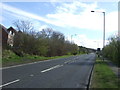
2
Footpath off the A695
Towards the Tyne Valley.
Image: © JThomas
Taken: 25 Apr 2013
0.15 miles
3
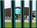
Hammerite Paint Factory, Prudhoe
View through the well painted railings. The works is on the site of the former Eltringham Brick and Tile Works which operated from 1881 to 1970 producing a range of fireclay bricks http://flic.kr/p/6f37y8 and salt-glazed pottery, sanitary pipes and vessels http://www.keystothepast.info/article/10339/Site-Details?PRN=N20872
There is another photo here Image
Image: © Andrew Curtis
Taken: 12 Sep 2011
0.17 miles
6
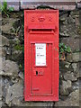
Edward VII postbox, North View Terrace, West Road (B6395)
Image: © Mike Quinn
Taken: 21 Oct 2008
0.18 miles
7
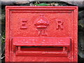
Edward VII postbox, North View Terrace, West Road (B6395) - royal cipher
See Image
Image: © Mike Quinn
Taken: 21 Oct 2008
0.18 miles
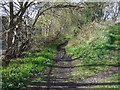
8
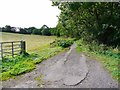
Byway to Eltringham
Woodland on the right hand side conceals the remains of two long rows of terraced houses for workers in the Eltringham Colliery and nearby brick works.
Image: © Andrew Curtis
Taken: 12 Sep 2011
0.19 miles
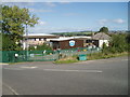
9
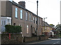
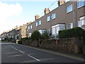
North View Terrace, West Road (B6395)
Shows the location of Image
Image: © Mike Quinn
Taken: 21 Oct 2008
0.19 miles
10
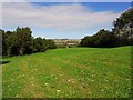
Meadow east of Eltringham Wood
View north-east over the Tyne valley towards Horsley on the far hilltop. This area, now used for public access is a reclaimed spoil tip from the former Eltringham Colliery.
Image: © Andrew Curtis
Taken: 12 Sep 2011
0.19 miles