IMAGES TAKEN NEAR TO
Piper Road, PRUDHOE, NE42 6AX
Introduction
This page details the photographs taken nearby to Piper Road, NE42 6AX by members of the Geograph project.
The Geograph project started in 2005 with the aim of publishing, organising and preserving representative images for every square kilometre of Great Britain, Ireland and the Isle of Man.

There are currently over 7.5m images from over14,400 individuals and you can help contribute to the project by visiting https://www.geograph.org.uk
Image Map
Images are licensed for reuse under creativecommons.org/licenses/by-sa/2.0
Notes
- Clicking on the map will re-center to the selected point.
- The higher the marker number, the further away the image location is from the centre of the postcode.
Image Listing (25 Images Found)
Images are licensed for reuse under creativecommons.org/licenses/by-sa/2.0
Image
Details
Distance
1
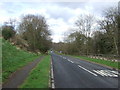
Castle View heading east
Along the Tyne towards Wylam.
Image: © JThomas
Taken: 25 Apr 2013
0.02 miles
2
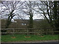
Footpath off Castle View
Above the Tyne near Ovingham.
Image: © JThomas
Taken: 25 Apr 2013
0.04 miles
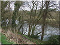
4
River Tyne from its southeast bank northeast of Ovingham
Image: © Luke Shaw
Taken: 14 Oct 2023
0.07 miles
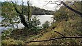
5
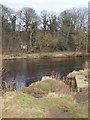
River Tyne at Ovingham
A flight of steps leads down to what appears to be an abutment on the north bank of the Tyne. The purpose of these steps is unknown.
Image: © Oliver Dixon
Taken: 23 Feb 2018
0.10 miles
6
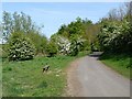
Tyne Riverside Park and Cycle Path, Prudhoe
The linear Tyne Riverside Park incorporates a cycle and foot path - here on the south bank of the river - which forms part of National Cycle Network route 72, otherwise known as Hadrian's Cycleway.
Image: © Oliver Dixon
Taken: 4 May 2011
0.12 miles
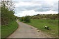
7

Hadrian's Cycleway, Tyne Riverside Park, Prudhoe
A popular off-road section, between Ovingham Bridge and Wylam, of the long distance cycle route 72. The wooded slope of the Spetchells is on the right.
Image: © Andrew Curtis
Taken: 29 Aug 2010
0.13 miles
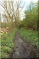
8
Footpath on The Spetchells
A footpath on the stretch of the grass on the southern bank of the River Tyne at Prudhoe.
Image: © Graham Robson
Taken: 22 Apr 2018
0.13 miles
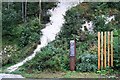
10
Water channel on The Spetchells
A water channel, possibly a drain, which flows across The Spetchells and into the River Tyne.
Image: © Graham Robson
Taken: 22 Apr 2018
0.14 miles