IMAGES TAKEN NEAR TO
Greenside, RYTON, NE40 4AF
Introduction
This page details the photographs taken nearby to NE40 4AF by members of the Geograph project.
The Geograph project started in 2005 with the aim of publishing, organising and preserving representative images for every square kilometre of Great Britain, Ireland and the Isle of Man.

There are currently over 7.5m images from over14,400 individuals and you can help contribute to the project by visiting https://www.geograph.org.uk
Image Map (Loading...)


Getting Data...Please wait
Leaflet Map data © OpenStreetMap
Images are licensed for reuse under creativecommons.org/licenses/by-sa/2.0
Notes
- Clicking on the map will re-center to the selected point.
- The higher the marker number, the further away the image location is from the centre of the postcode.
Image Listing (36 Images Found)
Images are licensed for reuse under creativecommons.org/licenses/by-sa/2.0
Image
Details
Distance
1
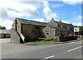
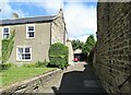
Converted farm building at Greenside
This is a former byre with barn over, converted to residential. Part of the former farmstead of Heathfield Farm in the centre of the village. It probably dates from the early 19th century when Greenside was a small agricultural village.
Image: © Robert Graham
Taken: 4 Jul 2022
0.02 miles
2
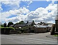
Heathfield Farm, Greenside
This is no longer a working farm, having been converted to residential use, probably some time ago. It is in the centre of the village and dates from the early or mid 19th century when Greenside was a small agricultural settlement.
Image: © Robert Graham
Taken: 4 Jul 2022
0.02 miles
3
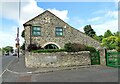
The Steadings, Greenside
This building stands on Lead Road, in the centre of the village. It seems to be one of the original early 19th century village houses, and was possibly a farmhouse. At this period, Greenside was a small agricultural settlement with some small scale coal mining. At the end of the century, larger collieries were opened and the village was greatly expanded.
Image: © Robert Graham
Taken: 4 Jul 2022
0.03 miles
4
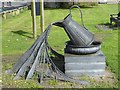
Art installation, Greenside
Not sure about the significance of this art installation in a small public park on Spen Lane, Greenside.
Image: © Oliver Dixon
Taken: 23 Sep 2016
0.03 miles
5
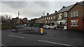
Junction of Spen Lane and Lead Road, Greenside
Image: © Anthony Foster
Taken: 1 Jan 2018
0.03 miles
6
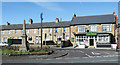
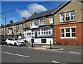
Old houses on Lead Road
On the front street in Greenside village. From old maps, these buildings date back to the early Victorian period, to when Greenside was just a small agricultural settlement.
Image: © Robert Graham
Taken: 4 Jul 2022
0.04 miles
7
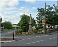
Greenside War memorial
This stands at the crossroads of Lead Road and Spen Lane in the centre of the village. Has names of the fallen from the two world wars engraved on it.
Image: © Robert Graham
Taken: 4 Jul 2022
0.04 miles
8
War memorial at Greenside
Greenside is a small village within Gateshead MBC.
Image: © Trevor Littlewood
Taken: 27 Sep 2018
0.04 miles
9
Nursery school, Greenside
On Lead Road, in the centre of the village.
Image: © Robert Graham
Taken: 4 Jul 2022
0.04 miles
10
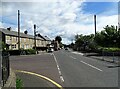
Greenside village centre
At the junction of Rockwood Hill Road, on the left, with Lead Road, the main street through the village.
Image: © Robert Graham
Taken: 4 Jul 2022
0.04 miles