IMAGES TAKEN NEAR TO
Ryton Village, RYTON, NE40 3QR
Introduction
This page details the photographs taken nearby to Ryton Village, NE40 3QR by members of the Geograph project.
The Geograph project started in 2005 with the aim of publishing, organising and preserving representative images for every square kilometre of Great Britain, Ireland and the Isle of Man.

There are currently over 7.5m images from over14,400 individuals and you can help contribute to the project by visiting https://www.geograph.org.uk
Image Map
Images are licensed for reuse under creativecommons.org/licenses/by-sa/2.0
Notes
- Clicking on the map will re-center to the selected point.
- The higher the marker number, the further away the image location is from the centre of the postcode.
Image Listing (68 Images Found)
Images are licensed for reuse under creativecommons.org/licenses/by-sa/2.0
Image
Details
Distance
1
The Grove, Ryton
There is a description and wider view here Image
Image: © Andrew Curtis
Taken: 7 Jan 2011
0.03 miles
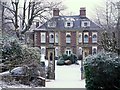
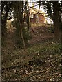
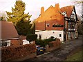
2
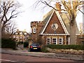
The Grove & Lodge House, Ryton
The large house is dated 1742 and has early C20th additions of round bows on the two end walls Image It has an ornate garden and castellated lodge house from the same period.
Tyne and Wear HER (8241): Ryton, Elvaston Road, The Grove http://www.twsitelines.info
The house was an old peoples' home until 1988 and is now again a private residence.
There is another photo here Image
Image: © Andrew Curtis
Taken: 3 Jan 2011
0.03 miles
4
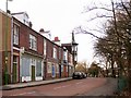
Former Elvaston Road Shops, Ryton
Another view of Image
The shops are shown when they were relatively new around 1910 here http://isee.gateshead.gov.uk/detail.php?t=objects&type=all&f=&s=elvaston&record=5
Image: © Andrew Curtis
Taken: 3 Jan 2011
0.03 miles
5
Jolly Fellows Inn, Elvaston Road, Ryton
This used to be the site of Elvaston Cottages and The Three Jolly Lads public house, built in a plain style http://isee.gateshead.gov.uk/detail.php?t=objects&type=all&f=&s=elvaston&record=3 http://isee.gateshead.gov.uk/detail.php?t=objects&type=all&f=&s=elvaston&record=2
In the early 1900s the Inn was demolished and a new Edwardian public house named the Jolly Fellows was built on the same site, between the cottages. The cottages were eventually demolished in 1953 http://isee.gateshead.gov.uk/detail.php?t=objects&type=all&f=&s=elvaston&record=1
Image: © Andrew Curtis
Taken: 3 Jan 2011
0.03 miles
6
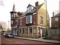
Former Lloyds Bank, Elvaston Road, Ryton
The west end of the former Victorian shopping parade on Elvaston Road Image, now mostly converted to residential use, but some of the shop fronts have been retained. One of the shops has an oriel window topped by a turret with a spire. It was built as an observatory.
The corner building, the former Lloyds Bank, was probably built as a house in the C19th century, was converted into a bank after 1912. It was disused by 1992 and was converted to a medical Centre.
http://www.pastscape.org.uk/hob.aspx?hob_id=1345785
Image: © Andrew Curtis
Taken: 3 Jan 2011
0.04 miles
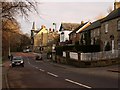
7
Junction with Northumberland Road, Ryton
Elvaston Road is on the left Image
Elvaston House and Manor House are set back from the road.
There is a photo from this location from around 1900 here http://isee.gateshead.gov.uk/detail.php?t=objects&type=all&f=&s=elvaston&record=0
Image: © Andrew Curtis
Taken: 7 Jan 2011
0.05 miles
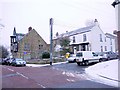
8
Barmoor Lane & Elvaston Road, Ryton
Looking east from the Village Green, Barmoor Lane turns into Elvaston Road at the distant junction with Northumberland Road. On the right is Town Farm Cottage, Town Farm House and the Granary. Next is Lynndale and Northumberland House on the corner. The shops in Elvaston Road are beyond the junction with the ornate tower and spire overlooking the street.
There is a photo dated c1896 from the same location here http://isee.gateshead.gov.uk/detail.php?t=objects&type=all&f=&s=ryton&record=168
Image: © Andrew Curtis
Taken: 3 Jan 2011
0.05 miles
9
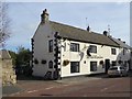
The Half Moon Inn, Ryton
In the last five years, a satellite dish has been added (see Image).
Image: © Oliver Dixon
Taken: 23 Sep 2016
0.06 miles
10
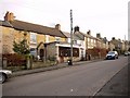
Whitewell Lane, Ryton
According to the C19th century local historian, William Bourn, Whitewell Lane got its name from a well on the west side of the street which was usually whitewashed on the outside. There is an old photo here http://isee.gateshead.gov.uk/detail.php?t=objects&type=all&f=&s=ryton&record=79
Image: © Andrew Curtis
Taken: 3 Jan 2011
0.06 miles