IMAGES TAKEN NEAR TO
Chesterton Road, SOUTH SHIELDS, NE34 9TW
Introduction
This page details the photographs taken nearby to Chesterton Road, NE34 9TW by members of the Geograph project.
The Geograph project started in 2005 with the aim of publishing, organising and preserving representative images for every square kilometre of Great Britain, Ireland and the Isle of Man.

There are currently over 7.5m images from over14,400 individuals and you can help contribute to the project by visiting https://www.geograph.org.uk
Image Map (Loading...)


Getting Data...Please wait
Leaflet Map data © OpenStreetMap
Images are licensed for reuse under creativecommons.org/licenses/by-sa/2.0
Notes
- Clicking on the map will re-center to the selected point.
- The higher the marker number, the further away the image location is from the centre of the postcode.
Image Listing (7 Images Found)
Images are licensed for reuse under creativecommons.org/licenses/by-sa/2.0
Image
Details
Distance
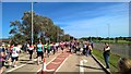
1
Footpath, Whiteleas
The former West Harton Mineral Line is now a foot and cycle path, part of 'Bede's Way'. This is the view looking north towards South Shields.
Image: © Alan Fearon
Taken: 18 Nov 2005
0.15 miles
2
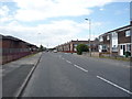
Galsworthy Road, South Shields
Looking west.
Image: © JThomas
Taken: 7 Jul 2018
0.15 miles
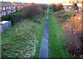
4

Path beside playing fields, Chuter Ede School
Looking south.
Image: © JThomas
Taken: 7 Jul 2018
0.21 miles
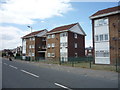
5
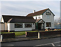
The New Mill
On John Reid Road, South Shields.
Image: © Chris Tweedy
Taken: 17 Jan 2006
0.21 miles