IMAGES TAKEN NEAR TO
Edgefield Avenue, NEWCASTLE UPON TYNE, NE3 3AA
Introduction
This page details the photographs taken nearby to Edgefield Avenue, NE3 3AA by members of the Geograph project.
The Geograph project started in 2005 with the aim of publishing, organising and preserving representative images for every square kilometre of Great Britain, Ireland and the Isle of Man.

There are currently over 7.5m images from over14,400 individuals and you can help contribute to the project by visiting https://www.geograph.org.uk
Image Map
Images are licensed for reuse under creativecommons.org/licenses/by-sa/2.0
Notes
- Clicking on the map will re-center to the selected point.
- The higher the marker number, the further away the image location is from the centre of the postcode.
Image Listing (22 Images Found)
Images are licensed for reuse under creativecommons.org/licenses/by-sa/2.0
Image
Details
Distance
3
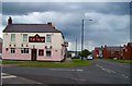
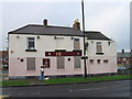
The Trap
This public house used to be called the Coxlodge, but local residents always called it the trap and so the brewery eventually gave in to local tradition and renamed it.
The name comes from the fact that the pitmen and quarry men who lived locally, (before it became so built up) used to race whippets around here and so the pub was called the trap.
Image: © Newbiggin Hall Scouts
Taken: 26 May 2007
0.17 miles
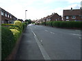
6
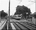
Level crossing at Fawdon, Tyne and Wear Metro
From the photograph, there do not seem to be any gates at this crossing. Whether this feature persists to the present is not known to me.
Image: © Dr Neil Clifton
Taken: 15 Jul 1981
0.19 miles
7

Former pub, Kenton Road, Coxlodge, Newcastle upon Tyne
The former Trap pub on the corner of Kenton Road and Carrfield Road. Image suggests that in 2007 the pub was still operating. By the time of Image in 2011 the pub had closed though some signage remained. The building is now almost entirely boarded up with all signage removed.
Image: © Graham Robson
Taken: 13 Apr 2020
0.19 miles
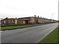
8
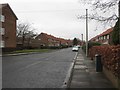
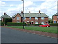
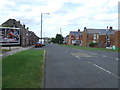
Edgefield Avenue, Kenton
A residential street in the Kenton area of Newcastle.
Image: © Graham Robson
Taken: 10 Feb 2018
0.20 miles
9
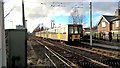
Metro train leaving Fawdon station heading east
Heading for South Hylton
Image: © Chris Morgan
Taken: 15 Feb 2018
0.21 miles
10
Coxlodge Methodist Church, Kenton Road, Coxlodge
Coxlodge Methodist Church sitting at the end of a terrace of houses on Kenton Road.
Image: © Graham Robson
Taken: 10 Feb 2018
0.21 miles