IMAGES TAKEN NEAR TO
Portberry Street, SOUTH SHIELDS, NE33 1QX
Introduction
This page details the photographs taken nearby to Portberry Street, NE33 1QX by members of the Geograph project.
The Geograph project started in 2005 with the aim of publishing, organising and preserving representative images for every square kilometre of Great Britain, Ireland and the Isle of Man.

There are currently over 7.5m images from over14,400 individuals and you can help contribute to the project by visiting https://www.geograph.org.uk
Image Map
Images are licensed for reuse under creativecommons.org/licenses/by-sa/2.0
Notes
- Clicking on the map will re-center to the selected point.
- The higher the marker number, the further away the image location is from the centre of the postcode.
Image Listing (34 Images Found)
Images are licensed for reuse under creativecommons.org/licenses/by-sa/2.0
Image
Details
Distance
1
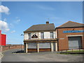
The now closed Commercial Hotel in Weetman Street, South Shields
Image: © Peter Robinson
Taken: 6 May 2012
0.07 miles
2
Ships on the Tyne, from Weetman Street, High Shields
Image: © Ian S
Taken: 3 Feb 2013
0.08 miles
3
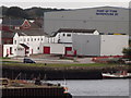
Port of Tyne Warehouse 20
Commercial area on the south bank of the River Tyne at South Shields.
www.portoftyne.co.uk
Image: © Colin Smith
Taken: 9 Sep 2012
0.09 miles
4
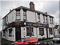
The Rosie (Rose & Crown)
Now very "remote" due to derelict ship yards and no housing. Surprised it's still open - glad it is.
Image: © Les Hull
Taken: 21 Nov 2010
0.10 miles
5
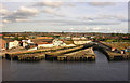
Former drydocks, South Shields
Abandoned drydocks litter the banks of the Tyne, this group at South Shields were once part of the Middle Docks or Tyne Engineering complex.
Image: © George Robinson
Taken: 21 Sep 2007
0.11 miles
6
West Docks, South Shields
Crane and warehousing in an area of the Port of Tyne.
www.portoftyne.co.uk
Image: © Colin Smith
Taken: 9 Sep 2012
0.12 miles
7
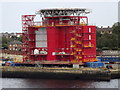
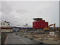
Port of Tyne, South Shields
Eye catching red cube on the quayside with what looks like a helicopter landing pad on its roof.
www.portoftyne.co.uk
Image: © Colin Smith
Taken: 9 Sep 2012
0.13 miles
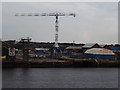
8
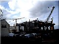
West Docks at High Shields
An oil rig structure under construction.
Image: © Russel Wills
Taken: 7 Aug 2014
0.13 miles
9
A drilling rig in West Dock, South Shields
Image: © Stanley Howe
Taken: 16 Apr 2011
0.13 miles
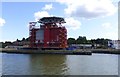
10
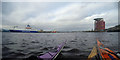
Port of Tyne
On one side a recently built building with what seems like a huge helipad on top, on the other, the DFDS ferry to the Netherlands. It used to be possible to take ferry from here to Norway Image but sadly (for those who would like to take a trailer full of sea kayaks to the far north) cheap air travel has put paid to that ferry, adding an extra 1300 kilometres to the drive. On our current journey, with the ebb tide from Derwenthaugh to South Shields, we've just rafted up to take a snack, as the sun has gone in and the wind is picking up a little, so a bit more energy is going to be needed to complete our trip.
Image: © Andy Waddington
Taken: 15 Oct 2017
0.14 miles