IMAGES TAKEN NEAR TO
North Street, JARROW, NE32 3PF
Introduction
This page details the photographs taken nearby to North Street, NE32 3PF by members of the Geograph project.
The Geograph project started in 2005 with the aim of publishing, organising and preserving representative images for every square kilometre of Great Britain, Ireland and the Isle of Man.

There are currently over 7.5m images from over14,400 individuals and you can help contribute to the project by visiting https://www.geograph.org.uk
Image Map
Images are licensed for reuse under creativecommons.org/licenses/by-sa/2.0
Notes
- Clicking on the map will re-center to the selected point.
- The higher the marker number, the further away the image location is from the centre of the postcode.
Image Listing (171 Images Found)
Images are licensed for reuse under creativecommons.org/licenses/by-sa/2.0
Image
Details
Distance
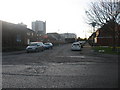
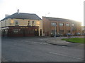
1
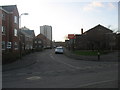
North Street in Jarrow
North Street in Jarrow looking west.
Viewed from the junction of Staple Road.
To the left on the picture North Street housing.
Centre on the picture Ellen Court highrise flats.
On the right of the picture the gable end of Jarrow Ex-Servicemen's Club & Institute Ltd.
Image: © Vin Mullen
Taken: 27 Nov 2009
0.02 miles
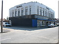
2
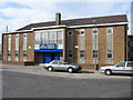
Ex-Servicemen's Club & Institute Ltd in Jarrow
Ex-Servicemen's Club & Institute Ltd in North Street, Jarrow
Image: © Vin Mullen
Taken: 16 Feb 2007
0.02 miles
3
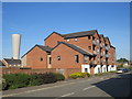
North Street, Jarrow
A recently-built apartment block in Jarrow. Looming behind, to the left of the image, is a ventilation chimney for the Tyne Tunnel.
Image: © Malc McDonald
Taken: 20 Sep 2019
0.03 miles
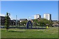
4
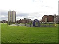
Play park, Ferry Street, Jarrow
A children's play park located on a large grassed area off Ferry Street in Jarrow. The grassed area is above the route of the Tyne Tunnels.
Image: © Graham Robson
Taken: 7 Oct 2017
0.05 miles
5
Ormonde Street in Jarrow
Ormonde Street in Jarrow looking West.
Viewed from Ferry Street.
On the left on the picture the back of Jarrow Ex-Servicemen's Club & Institute Ltd.
Left of centre on the picture Ellen Court highrise flats.
Centre of the picture old Burton's Building.
Image: © Vin Mullen
Taken: 27 Nov 2009
0.05 miles
6
Ormonde Street in Jarrow (Burton the Tailor)
Old Burton the Tailor shop in Ormonde Street in Jarrow.
The building must be at least 85 years old.
This is the only old building that is left in Ormonde Street now, of what used to be the main shopping thoroughfare in Jarrow.
Image: © Vin Mullen
Taken: 1 May 2007
0.06 miles
8
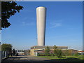
Tyne Tunnel ventilation, Jarrow
This tall chimney is a ventilation shaft, enabling traffic fumes to disperse from the Tyne Tunnel which passes below.
Image: © Malc McDonald
Taken: 20 Sep 2019
0.06 miles
9
Grange Road in Jarrow
Grange Road in Jarrow viewed from Staple Road.
On the left of the picture the Royal Oak (Longbar) public house.
And on the right on the picture Mid Tyne Activity Centre
Image: © Vin Mullen
Taken: 27 Nov 2009
0.07 miles
10
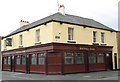
The Royal Oak
Of the Pubs & Clubs of Jarrow only 12 Public Houses and 6 Social Clubs are still here today. (Researched by Vin Mullen)
Abbey House (Abbey Brewery) Bridge Street /Albert Road. Nicknamed the ‘Pub with no beer’ (Demolished).
Albert Hall 60 Ellison Street (Demolished).
Alberta Social Club Railway Street. Formerly Albert Road / Park Road.
The Albion Hotel 76-80 Walter Street. Now The Jarrow Crusaders.
The Alexandra Hotel (1) 248 High Street. Renamed O’Malley's Irish Bar then reverted back to The Alexandra Hotel.
The Alexandra (2) Leam Lane (Demolished).
Alkali 13 Swinburne Street. Renamed Zenith then reverted back to Alkali. Now the Alkali Business Centre (Offices).
Allison Arms 31 Straker Street. Now up for sale.
Alnwick Castle Hotel Grange Road / Walter Street (Demolished).
Bell Rock Inn 28-30 Nixon Street (Demolished).
The Ben Lomond Hotel & Restaurant Grange Road West. Renamed Viking then reverted back to The Ben Lomond.
Billiard Saloon 56 Clayton Street (Demolished).
Boldon Lad Hedworth Lane.
The Borough Arms Hotel 28-30 North Street. Formerly Turf Hotel (Demolished).
Brett's Wine Bar (Arndale Arcade) Closed.
Bridge Inn Don Road. Nicknamed McKagney's (Demolished).
British Legion Club Ormonde Street (Demolished).
The Bull Chillingham Terrace. Renamed Chillingham Arms (Demolished).
Burton House Ellison Place (Demolished).
Cavalier Club Market Square / North Street. Old Co-op (Demolished).
Chain and Anchor Inn East Jarrow (Demolished).
Jarrow Conservative Club 50 Bede Burn Road.
Commercial Hotel 1 Commercial Road. Renamed The Tunnel Tavern then The Gas Light (Demolished 2008).
Cottage Hotel 5 Caledonian Road (Demolished).
County Hotel 78 Ormonde Street. Formerly Albion Club (Demolished).
Crown & Anchor 29-31 Chapel Road.
Deneside Catholic & Social Club St. Joseph's Way /Durham Drive (Demolished).
The Duke of Wellington High Street. Renamed Bede's Ale House (Demolished).
East Ferry Inn 1 Quay Corner. Nicknamed the Spike (Demolished).
Ellison Arms. Ellison Street / Western Road (Demolished).
Ellison RAOB Club Ellison Street. Moved to new premises Ellison Social Club at 96 Ellison Street. Nickname the Buff's.
Engineers Arms 87-89 Ormonde Street (Demolished).
Jarrow Excelsior Working Men’s Club Market Square (Demolished).
Jarrow Ex-Servicemen's Club & Institute Ltd 18-22 North Street. Formerly at Grange Road /Ferry Street.
Forge & Hammer Inn 74-76 North Street. Renamed The Cottage (Demolished).
Forrester’s Arms Ellison Street /Ellison Place. Nicknamed Red Wine Shop (Demolished).
Franchi's Nightclub Arndale Arcade (Demolished).
Globe Hotel 4 Princess Street (Demolished).
The Golden Fleece (1) Commercial Road /Pit Heap (Demolished).
The Golden Fleece (2) 61 Ferry Street (Demolished).
Golden Lion Inn 14-16 Walter Street. Nickname Johnnies.
The Greyhound Hedworth Lane.
Grange Hotel Grange Road /Grey Street (Demolished).
The Hall Cottage High Street (Demolished).
Hall’s Dock Curlew Road (Demolished).
The Hive Inn Straker Street (Demolished about 1890).
Hylton Castle 76-78 High Street (Demolished).
Independent Labour Party Club Walter Street (Demolished).
Jarrow Labour & Social Club Kent Street / Park Road. Renamed Park Road Social Club (Demolished).
Liberal Club Station Street (Demolished).
Lord Nelson (1) 62-64 Walter Street (Demolished).
The Lord Nelson (2) Monkton Lane. Monkton Village.
Mechanics Institute Ellison Street. Now the Civic Hall (Closed).
Murray's Club Fellgate Avenue. Formerly Botto's Club.
Neon Social Club & Institute Ltd Nairn Street. Formerly 2-4 Grey Street called the Jarrow Gas Workers Club. Mullen's Club took it over at Grange Road /Grey Street.
North Eastern Hotel Clayton Street /Wear Street. Renamed The North (Demolished).
Prince of Wales Calf Close Lane. Formerly in Drury Lane /Commercial Road.
Queens Arms Union Street /Ormonde Street/Shakespeare Street backlane. Now The Queens.
The Queens Head Hotel 70 Monkton Road (Demolished).
Queens Hotel Wear Street /Western Road. Renamed the Jarrow Lad (Demolished).
Red Hackle Perth Avenue.
The Robin Hood Primrose Hill. On the 1850 map it was down as The Robin Hood and Little John.
Rolling Mill Western Road. Now a Children's nursery.
Rose & Crown Nixon Street/Ellison Place (Demolished).
The Royal Market Square/North Street/South Street (Demolished).
Royal Billiard Saloon Market Square (Demolished).
The Royal Oak (1) 115-117 Grange Road. Nickname the Longbar.
The Royal Oak (2) 49 Princess Street (Demolished).
St. Bede's Catholic Institute Chapel Road (Demolished).
St. Bede's Parochial Institute Albert Road / Hill Street. Formerly the Co-op Bank. Now St. Bede's Chambers.
St. Mary's RC Social Club Stanhope Road. Renamed Low Simonside Social Club (Demolished).
Staith House Pearson Place/Curlew Road (Demolished).
Ship Inn Tyne Street. Former Dunkirk Place (Demolished about 1910).
Station Hotel 1 Ellison Street (Demolished).
Stirling Castle Ellison Place (Demolished).
Jarrow Tariff Reform & Unionist Club Ormonde Street (Demolished).
Strakers Arms Inn East Jarrow (Demolished).
Telegraph Hotel 164-166 High Street (Demolished).
Theatre Royal Market Square - 2 bars (Demolished).
Tynemouth Castle 68 Ormonde Street (Demolished).
Union Street Club Rooms Union Street (Demolished).
Victoria Hotel 79 Ferry Street. Nicknamed the Harbour Lights (Demolished).
Victory Club Nixon Street (Demolished).
Wellington Hotel High Street. Forerunner of the Duke of Wellington (Demolished).
Western Hotel Western Road. Renamed Palmers Tavern. Now The Spice Indian Restaurant.
(update February 2011)
Image: © Vin Mullen
Taken: 22 Jun 2008
0.08 miles