IMAGES TAKEN NEAR TO
Cliffords Fort, NORTH SHIELDS, NE30 1JE
Introduction
This page details the photographs taken nearby to Cliffords Fort, NE30 1JE by members of the Geograph project.
The Geograph project started in 2005 with the aim of publishing, organising and preserving representative images for every square kilometre of Great Britain, Ireland and the Isle of Man.

There are currently over 7.5m images from over14,400 individuals and you can help contribute to the project by visiting https://www.geograph.org.uk
Image Map
Images are licensed for reuse under creativecommons.org/licenses/by-sa/2.0
Notes
- Clicking on the map will re-center to the selected point.
- The higher the marker number, the further away the image location is from the centre of the postcode.
Image Listing (219 Images Found)
Images are licensed for reuse under creativecommons.org/licenses/by-sa/2.0
Image
Details
Distance
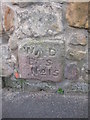
2
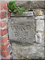
Old Boundary Marker
War Department Boundary Marker set in the northwest corner of the former Cliffords Fort, now The Barracks Building, accessible from the car park of the Staithe House PH, North Shields. Inscribed W ↑ D / BS / No. 8.
Milestone Society National ID: NB_WDNSH08em
Image: © Mike Rayner
Taken: 21 Jul 2019
0.02 miles
3
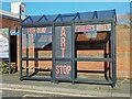
Fiddler’s Green Art Stop, Fish Quay, North Shields
Launched in August 2018 this bus stop shelter is intended to give the opportunity for artists and writers to display some of their work on the small poster site situated on the inside of the shelter whilst at the same time giving passengers something to look at/read whilst waiting for their bus.
Image: © Geoff Holland
Taken: 30 Jan 2024
0.02 miles
4
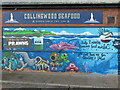
Artwork, Collingwood Seafood, Cliffords Fort, North Shields
This colourful piece of artwork perfectly achieves its objective in attracting customers to the adjoining retail unit. What more does the prospective customer need to know? For a selection of detailed free to download walking routes in the area visit www.northtynesidewalks.co.uk
Image: © Geoff Holland
Taken: 25 Nov 2020
0.02 miles
6
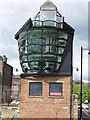
Former Smokehouse, Fish Quay, North Shields
This historic smokehouse which sits on the 17th-century walls of Clifford's Fort has recently been converted into a living space and studio by a local architect. A striking feature of the design is a triple-glazed frontage facing the sea made from 40 curved van windscreens, which has been likened to the sails of a ship catching the wind. The glazing will provide a growing zone for salad crops, which will be irrigated by the water used to raise fast-growing African tilapia fish on the ground floor. The energy-efficient, super-insulated building also has roof solar panels and an air source heat pump, and the additions have used 100-year-old Australian eucalyptus wood which was imported for use as railway sleepers. The curved windows which form the most part of the glazing are made from the windscreens from Ford Transit vans. I am not sure if they are new or recovered from old vehicles.
For a selection of detailed free to download walking routes in the area visit www.northtynesidewalks.co.uk
Image: © Geoff Holland
Taken: 2 Jul 2019
0.03 miles
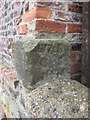
7
Old Boundary Marker
War Department Boundary Marker set in the foot of a stone wall on the north side of the site of Cliffords Fort and Ballards smokehouse, Union Road, North Shields. Inscribed W ↑ D / BS / No. 15. Grade II Listed https://historicengland.org.uk/listing/the-list/list-entry/1299778.
Milestone Society National ID: NB_WDNSH15em
Image: © Mike Rayner
Taken: 21 Jul 2019
0.03 miles
8
Old Boundary Marker
War Department Boundary Marker set in the west face of the northwest corner of the site of Cliffords Fort and Ballards smokehouse, Union Road, North Shields. It’s at the foot of a brick wall where it ends above a stone wall. Inscribed W ↑ D / BS / No. 16. Grade II Listed https://historicengland.org.uk/listing/the-list/list-entry/1299778.
Milestone Society National ID: NB_WDNSH16em
Image: © Mike Rayner
Taken: 21 Jul 2019
0.03 miles
9
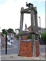
'Dolphin Mooring Post', Union Road, North Shields
Outside the New Dolphin Public House, the 'Dolphin Mooring Post' sculpture was created in 1993 by Freeform Artists with help of the Community of John Spence School. It is based on mooring posts traditionally used on the River Tyne. The work includes a cormorant sitting on top drying its wings. The cormorant, known affectionately as `Colin`, was sculpted by artist Richard Broderick and was added some time after the main structure was installed.
http://www.cheviotwalks.org/northtynesidewalks/art1.html
Brewhouse Bank rises up from the Fish Quay behind.
Image: © Andrew Curtis
Taken: 28 Jul 2013
0.03 miles
10
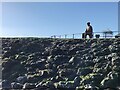
Fidlder’s Green Memorial, Fish Quay
This memorial, photographed here from the small sandy beach at the southern end of The Flats, was created by Ray Lonsdale, and honours the fishermen who died whilst doing their job after leaving the port of North Shields. It was unveiled in September 2017. It can also be seen, closer at hand, at https://www.geograph.org.uk/photo/5835944.
Image: © Geoff Holland
Taken: 30 Jan 2024
0.03 miles