IMAGES TAKEN NEAR TO
Bell Street, NORTH SHIELDS, NE30 1HF
Introduction
This page details the photographs taken nearby to Bell Street, NE30 1HF by members of the Geograph project.
The Geograph project started in 2005 with the aim of publishing, organising and preserving representative images for every square kilometre of Great Britain, Ireland and the Isle of Man.

There are currently over 7.5m images from over14,400 individuals and you can help contribute to the project by visiting https://www.geograph.org.uk
Image Map
Images are licensed for reuse under creativecommons.org/licenses/by-sa/2.0
Notes
- Clicking on the map will re-center to the selected point.
- The higher the marker number, the further away the image location is from the centre of the postcode.
Image Listing (227 Images Found)
Images are licensed for reuse under creativecommons.org/licenses/by-sa/2.0
Image
Details
Distance
1
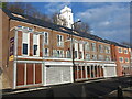
Waterfront Apartments, Bell Street, North Shields
This piece of land in Bell Street, which at various times in the past had been home to the Blue Bell Inn, a number of garages and a workshop, had stood vacant for a number of years prior to the development of these apartments commencing in 2018. The plans originally included two commercial units to the ground floor although subsequently these were replaced by additional car parking with locally-inspired art fitted into the external walls. For a selection of detailed free to download walking routes in the area visit www.northtynesidewalks.co.uk
Image: © Geoff Holland
Taken: 25 Nov 2020
0.02 miles
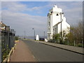
2
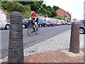
Bell Street, North Shields
Western Quay is protected by decorated iron bollards suitable for the Fish Quay.
Image: © Andrew Curtis
Taken: 28 Jul 2013
0.03 miles
3
Fish quay high light.
Attached to adjacent building, built 1807.
Image: © Steve Fareham
Taken: 15 Jul 2007
0.03 miles
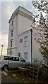
4
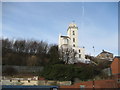
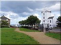
High Light
This curious building is really a lighthouse perched on a hill in North Shields. It assists with safe passage for shipping on the River Tyne
Image: © Chris Heaton
Taken: 23 Jan 2007
0.04 miles
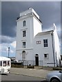
5
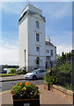
The old, new High Light, North Shields
Built in 1808 to replace earlier lights. This and the Low Light nearer the river and Fish Quay were necessary to guide sailors into the Tyne before the river was dredged and the piers built to shelter the harbour. See Wiki for more information on the history; https://en.wikipedia.org/wiki/High_and_Low_Lights_of_North_Shields
No longer active and a nice house with a wonderful view. The two lights still assist vessels to take a daytime line of sight into the river.
Image: © Chris Morgan
Taken: 30 Oct 2016
0.04 miles
6
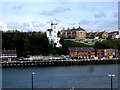
High and Low Lights
The tall white tower in the foreground is the High Light. Mariners entering the piers line up the light with its twin Low Light down on the Fish Quay, this gives them a safe channel into the river.
Image: © Ken Brown
Taken: 16 Apr 2005
0.05 miles
7
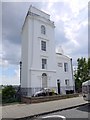
High Light, North Shields
Lighthouse by John Stokoe for Trinity House, Newcastle upon Tyne, dated 1808 and attached house 1860. By lining up the High Light and the Low Light, down by the Fish Quay, ships were guided to enter the mouth of the River Tyne through a safe channel.
Image: © Andrew Curtis
Taken: 28 Jul 2013
0.05 miles
9
High Light, North Shields
Viewed across the Tyne from South Shields.
Image: © Stanley Howe
Taken: 16 Apr 2011
0.05 miles
10
Entrance to Dockwray Square, North Shields
Showing High and Low Lights.
Image: © Andrew Curtis
Taken: 28 Jul 2013
0.05 miles