IMAGES TAKEN NEAR TO
Forsyth Street, NORTH SHIELDS, NE29 8ED
Introduction
This page details the photographs taken nearby to Forsyth Street, NE29 8ED by members of the Geograph project.
The Geograph project started in 2005 with the aim of publishing, organising and preserving representative images for every square kilometre of Great Britain, Ireland and the Isle of Man.

There are currently over 7.5m images from over14,400 individuals and you can help contribute to the project by visiting https://www.geograph.org.uk
Image Map
Images are licensed for reuse under creativecommons.org/licenses/by-sa/2.0
Notes
- Clicking on the map will re-center to the selected point.
- The higher the marker number, the further away the image location is from the centre of the postcode.
Image Listing (14 Images Found)
Images are licensed for reuse under creativecommons.org/licenses/by-sa/2.0
Image
Details
Distance
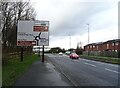
1

New York: postbox № NE29 59, New York Road
A large, George VI-reign postbox standing outside the post office.
Image: © Chris Downer
Taken: 7 Aug 2011
0.02 miles
2

New York and Murton Social Club
A social club in the New York area of North Tyneside.
Image: © Graham Robson
Taken: 24 Feb 2018
0.04 miles
3
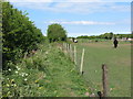
Public Footpath near New York
This is the section of footpath shown at https://www.geograph.org.uk/photo/6459468 but viewed from the opposite end where it seems, at first sight, to offer a clearer route to the gate shown at https://www.geograph.org.uk/photo/6459463. For a selection of detailed free to download walking routes in the area visit www.northytnesidewalks.co.uk
Image: © Geoff Holland
Taken: 1 May 2020
0.08 miles
4
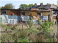
Stables, Murton Lane, New York
This is a rear view of the small stables which have their entrance on Murton Lane. The make do, patchwork boundary fence suggests that this is very much a low cost operation. For a selection of detailed free to download walking routes in the area visit www.northtynesidewalks.co.uk
Image: © Geoff Holland
Taken: 1 May 2020
0.08 miles
5
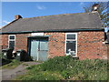
Old Forge (Smithy), Brookland Terrace, New York
It is thought that a forge has stood on this site since the mid-18th century. However, as this point was once an important medieval crossroads linking the monasteries of Lindisfarne and Jarrow, it is conceivable that a forge stood here long before the mid-18th century. When the first Ordnance Survey Six-Inch map of the area was published in 1865, the forge was not named on the map although the adjacent building was referred to as the 'Traveller's Rest (P.H.)'. When the 1898 Ordnance Survey map was published, the public house no longer existed and the only property shown and named on the map at this point was a 'Smithy'. This gives weight to the belief that the current brick building was built at some time between the publication of the two maps. For a selection of detailed free to download walking routes in the area visit www.northtynesidewalks.co.uk
Image: © Geoff Holland
Taken: 1 May 2020
0.09 miles
6
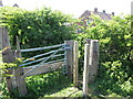
Gate near New York
This rather makeshift gate/gap in the fence leads to a housing estate on the north side of New York. It lies on the line of a public footpath https://www.geograph.org.uk/photo/6459449 which continues, in more or less a straight line, beyond the gate although that section of the footpath now seems to be little-walked. For a selection of detailed free to download walking routes in the area visit www.northtynesidewalks.co.uk
Image: © Geoff Holland
Taken: 1 May 2020
0.10 miles
7
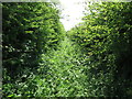
Public Footpath near New York
This is the section of public footpath referred to at https://www.geograph.org.uk/photo/6459463 which now appears to be little-utilised. It seems that walkers prefer to take the alternative route through the gap in the fence leading to the Housing Estate at New York. Both routes culminate at the same point. For a selection of detailed free to download walking routes in the area visit www.northtynesidewalks.co.uk
Image: © Geoff Holland
Taken: 1 May 2020
0.10 miles
8
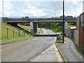
Underbridge on Westminster Avenue
Running south from New York, Westminster Avenue passes underneath the A191.
Image: © Oliver Dixon
Taken: 5 Aug 2016
0.10 miles
9
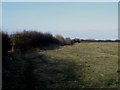
Footpath between New York and Murton
A footpath crosses farmland connecting the estate of New York and the small village of Murton.
Image: © Graham Robson
Taken: 24 Feb 2018
0.15 miles