IMAGES TAKEN NEAR TO
Hamar Close, NORTH SHIELDS, NE29 7XB
Introduction
This page details the photographs taken nearby to Hamar Close, NE29 7XB by members of the Geograph project.
The Geograph project started in 2005 with the aim of publishing, organising and preserving representative images for every square kilometre of Great Britain, Ireland and the Isle of Man.

There are currently over 7.5m images from over14,400 individuals and you can help contribute to the project by visiting https://www.geograph.org.uk
Image Map
Images are licensed for reuse under creativecommons.org/licenses/by-sa/2.0
Notes
- Clicking on the map will re-center to the selected point.
- The higher the marker number, the further away the image location is from the centre of the postcode.
Image Listing (11 Images Found)
Images are licensed for reuse under creativecommons.org/licenses/by-sa/2.0
Image
Details
Distance
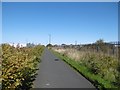
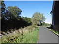
1
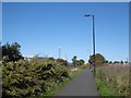
Waggonway conversion
A cycle/footpath using the former Backworth Colliery mineral line by West Chirton. The parallel railway is now a preserved line.
Image: © Richard Webb
Taken: 1 Oct 2015
0.05 miles
2
Cycle route on old railway at Percy Main
National Cycle Route 10, part of the Reiver's Cycle Route follows the line of the old Blyth and Tyne Railway and Seaton Burn Waggonway. The North Tyne Steam Railway, a heritage railway, runs alongside.
Image: © Oliver Dixon
Taken: 4 Dec 2013
0.06 miles
3
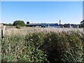
Undeveloped land, West Chirton
An industrial area beside the North Tyneside Steam Railway and cycle path.
Image: © Richard Webb
Taken: 1 Oct 2015
0.10 miles
4
North Tyneside Steam Railway
Taken near the East Howden end of the line from the A193 looking north. National Cycle route 10 is on the right.
Image: © Alan Fearon
Taken: 5 Nov 2005
0.14 miles
5
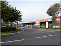
Second Avenue, Tyne Tunnel Trading Estate
Featuring JTF Mega Discount Warehouse.
Image: © Oliver Dixon
Taken: 30 Sep 2015
0.16 miles
6
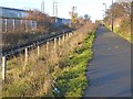
Backworth Colliery Railway
Now a cycle path. Behind the Japanese Knotweed on the left is the North Tyneside Steam Railway which uses the route of the Seatonburn Waggonway. On the right is an industrial area where at the time was awaiting redevelopment with the network of roads left after demolition of older units.
Image: © Richard Webb
Taken: 1 Oct 2015
0.19 miles
7
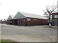
Bus Depot, Percy Main
A large site on Norham Road operated as a bus depot by Go North East.
Image: © Graham Robson
Taken: 1 May 2017
0.22 miles
8
Cycle route on old railway at West Chirton
National Cycle Route 10, part of the Reiver's Cycle Route follows the line of the old Blyth and Tyne Railway and Seaton Burn Waggonway. The North Tyne Steam Railway, a heritage railway, runs alongside. The route here passes between trading estates on both sides.
Image: © Oliver Dixon
Taken: 4 Dec 2013
0.22 miles
9

Also for in-line skaters
Alternative use for the cycle path National Cycle Route 10, part of the Reiver's Cycle Route which follows the line of the old Blyth and Tyne Railway and Seaton Burn Waggonway. The bridge in the background carries the Coast Road.
Image: © Oliver Dixon
Taken: 4 Dec 2013
0.22 miles
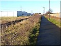
10
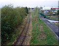
Path and North Tyneside Steam Railway
A preserved railway on the site of the Seatonburn Waggonway and the Blyth and Tyne Railway. There were two railways running beside each other here and one (Backworth Colliery railway) has been converted into the path used by the Reiver's Route. This is a coast to coast route through Kielder Forest.
The railway is shown as operational on the 1976 1:50,000 Ordnance Survey map.
Image: © Richard Webb
Taken: 1 Oct 2015
0.23 miles