IMAGES TAKEN NEAR TO
Earsdon View, NEWCASTLE UPON TYNE, NE27 0SX
Introduction
This page details the photographs taken nearby to Earsdon View, NE27 0SX by members of the Geograph project.
The Geograph project started in 2005 with the aim of publishing, organising and preserving representative images for every square kilometre of Great Britain, Ireland and the Isle of Man.

There are currently over 7.5m images from over14,400 individuals and you can help contribute to the project by visiting https://www.geograph.org.uk
Image Map
Images are licensed for reuse under creativecommons.org/licenses/by-sa/2.0
Notes
- Clicking on the map will re-center to the selected point.
- The higher the marker number, the further away the image location is from the centre of the postcode.
Image Listing (20 Images Found)
Images are licensed for reuse under creativecommons.org/licenses/by-sa/2.0
Image
Details
Distance
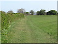
1
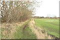
Footpath crossing farmland
A public crossing the farmland separating Shiremoor and South Wellfield.
Image: © Graham Robson
Taken: 24 Nov 2018
0.06 miles
2
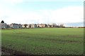
Farmland on the edge of Shiremoor
An arable field containing an autumn sown cereal crop on the edge of Shiremoor.
Image: © Graham Robson
Taken: 24 Nov 2018
0.06 miles
3
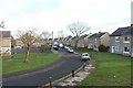
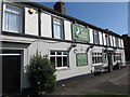
Grange Avenue, Shiremoor
A residential street in Shiremoor with semi detached houses on either side of the road.
Image: © Graham Robson
Taken: 24 Nov 2018
0.14 miles
4
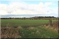
Farmland between Shiremoor and South Wellfield
The belt of farmland separating Shiremoor and South Wellfield. Earsdon is visible in the distance.
Image: © Graham Robson
Taken: 24 Nov 2018
0.14 miles
5
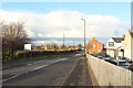
Park Lane, Shiremoor
Looking north along Park Lane in Shiremoor.
Image: © Graham Robson
Taken: 24 Nov 2018
0.14 miles
7
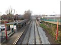
Shiremoor Metro Station
Looking down from a road bridge crossing the tracks to the station at Shiremoor on the Tyne and Wear Metro line through North Tyneside.
Image: © Graham Robson
Taken: 10 Dec 2016
0.17 miles
8
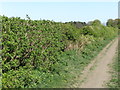
Public Footpath near Shiremoor
This lovely section of public footpath leads from Earsdon Road to Otterburn Avenue, South Wellfield, and follows the course of an old path which, at the time of the publication of the Ordnance Survey Six-Inch map of the area in 1898, served the now-disappeared Earsdon Grange Cottages. For a selection of detailed free to download walking routes in the area visit www.northtynesidewalks.co.uk
Image: © Geoff Holland
Taken: 22 Apr 2020
0.17 miles
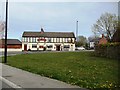
9
The Grey Horse Pub, Shiremoor
This pub stands at the old cross roads which lead, in one direction to Newcastle, in another direction to Blyth, and in the third direction to North Shields. The old cross roads are marked with an old signpost which is a well-preserved reminder of what road signs were like before they were redesigned by Margaret Calvert in the 1960s. When the first Ordnance Survey Six-Inch map of the area was published in 1865, the pub, then referred to as 'The Grey Horse Inn', along with adjoining Bertram Place were the only buildings standing at this point. For a selection of detailed free to download walking routes in the area visit www.northtynesidewalks.co.uk
Image: © Geoff Holland
Taken: 22 Apr 2020
0.18 miles
10
Public Footpath near Shiremoor
This public footpath leads from Earsdon Road to Otterburn Avenue, South Wellfield, and follows the course of an old path which, at the time of the publication of the Ordnance Survey Six-Inch map of the area in 1898, served the now-disappeared Earsdon Grange Cottages. It follows quickly after the section of public footpath shown at https://www.geograph.org.uk/photo/6451099. For a section of detailed free to download walking routes in the area visit www.northtynesidewalks.co.uk
Image: © Geoff Holland
Taken: 22 Apr 2020
0.18 miles