IMAGES TAKEN NEAR TO
Lower Crone Street, NEWCASTLE UPON TYNE, NE27 0HN
Introduction
This page details the photographs taken nearby to Lower Crone Street, NE27 0HN by members of the Geograph project.
The Geograph project started in 2005 with the aim of publishing, organising and preserving representative images for every square kilometre of Great Britain, Ireland and the Isle of Man.

There are currently over 7.5m images from over14,400 individuals and you can help contribute to the project by visiting https://www.geograph.org.uk
Image Map
Images are licensed for reuse under creativecommons.org/licenses/by-sa/2.0
Notes
- Clicking on the map will re-center to the selected point.
- The higher the marker number, the further away the image location is from the centre of the postcode.
Image Listing (24 Images Found)
Images are licensed for reuse under creativecommons.org/licenses/by-sa/2.0
Image
Details
Distance
1
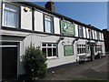
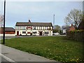
The Grey Horse Pub, Shiremoor
This pub stands at the old cross roads which lead, in one direction to Newcastle, in another direction to Blyth, and in the third direction to North Shields. The old cross roads are marked with an old signpost which is a well-preserved reminder of what road signs were like before they were redesigned by Margaret Calvert in the 1960s. When the first Ordnance Survey Six-Inch map of the area was published in 1865, the pub, then referred to as 'The Grey Horse Inn', along with adjoining Bertram Place were the only buildings standing at this point. For a selection of detailed free to download walking routes in the area visit www.northtynesidewalks.co.uk
Image: © Geoff Holland
Taken: 22 Apr 2020
0.02 miles
2
The Grey Horse, Shiremoor
The Grey Horse, a pub on Park Lane in Shiremoor.
Image: © Graham Robson
Taken: 10 Dec 2016
0.03 miles
3
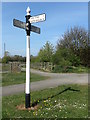
Old Direction Signpost, Shiremoor
This signpost is a reminder of what road signs were like before they were redesigned by Margaret Calvert in the 1960s. Dating back to the late 18th or early 19th century, this signpost was manufactured by Smith, Patterson & Co. of Blaydon and is Grade II Listed. Since the construction of the Shiremoor By-pass in 2009, the junction where the sign stands has been reconfigured with the result that the sign now performs a less functional role. For a selection of detailed free to download walking routes in the area visit www.northtynesidewalks.co.uk
Image: © Geoff Holland
Taken: 22 Apr 2020
0.05 miles
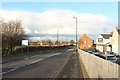
4

The Northern end of Park Lane, Shiremoor
Looking towards the road junction at the northern end of Park Lane. An old signpost gives distances to several local places in the foreground.
Image: © Graham Robson
Taken: 10 Dec 2016
0.05 miles
5
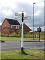
Old Direction Sign - Signpost by Earsdon Road, Whitley Bay parish
Cone on ball finial - 3 arms; Pioneer by the UC road, in parish of Whitley Bay (North Tyneside District), Shiremoor, Earsdon Road junction with Park Lane, on verge, East side of road.
Grade II listed.
List Entry Number: 1408200 https://historicengland.org.uk/listing/the-list/list-entry/1408200
To be surveyed.
Milestone Society National ID: NB_NZ3171
Image: © Milestone Society
Taken: Unknown
0.05 miles
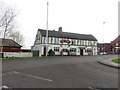
7
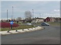
Shiremoor By-pass and the Grey Horse public house
At the western end of the Shiremoor By-pass, a section of the A186 opened in January 2009.
Image: © Oliver Dixon
Taken: 23 Feb 2012
0.10 miles
8
Park Lane, Shiremoor
Looking north along Park Lane in Shiremoor.
Image: © Graham Robson
Taken: 24 Nov 2018
0.13 miles
9
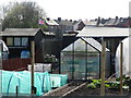
Allotments on Earsdon Road near Shiremoor
When the first Ordnance Survey Six-Inch map of the area was published in 1865, the area now occupied by these allotments was farm land and the name 'Shiremoor' did not feature anywhere on the map. The only immediately surrounding property at that time was the Grey Horse Inn (Pub) and Bertram Place. Whilst the history of allotments goes back many centuries, it was not until the Small Holdings and Allotments Act 1908 came into force that local authorities were legally obliged to provide "sufficient allotments according to demand". This duty was further extended with the passing of the Land Settlement Facilities Act 1919 with the rights of allotment holders being strengthened by the Allotments Act 1922. However, the most important change was introduced when the Allotments Act 1925 established statutory allotments which local authorities could not sell off or covert to other uses without Ministerial consent. For a selection of detailed free to download walking routes in the area visit www.northtynesidewalks.co.uk
Image: © Geoff Holland
Taken: 22 Apr 2020
0.13 miles
10
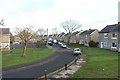
Grange Avenue, Shiremoor
A residential street in Shiremoor with semi detached houses on either side of the road.
Image: © Graham Robson
Taken: 24 Nov 2018
0.15 miles