IMAGES TAKEN NEAR TO
Dachet Road, WHITLEY BAY, NE25 9UQ
Introduction
This page details the photographs taken nearby to Dachet Road, NE25 9UQ by members of the Geograph project.
The Geograph project started in 2005 with the aim of publishing, organising and preserving representative images for every square kilometre of Great Britain, Ireland and the Isle of Man.

There are currently over 7.5m images from over14,400 individuals and you can help contribute to the project by visiting https://www.geograph.org.uk
Image Map (Loading...)


Getting Data...Please wait
Leaflet Map data © OpenStreetMap
Images are licensed for reuse under creativecommons.org/licenses/by-sa/2.0
Notes
- Clicking on the map will re-center to the selected point.
- The higher the marker number, the further away the image location is from the centre of the postcode.
Image Listing (11 Images Found)
Images are licensed for reuse under creativecommons.org/licenses/by-sa/2.0
Image
Details
Distance
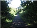
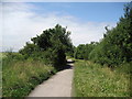
1
Waggonways
The former Avenue Branch of the Blyth and Tyne Railway, now a cycle track and footpath.
Image: © Mick Garratt
Taken: 3 May 2015
0.10 miles
2
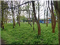
Public Woodland adjacent to the Waggonways
Image: © Mick Garratt
Taken: 3 May 2015
0.10 miles
3

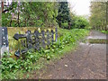
Signage, Waggonways, Whitley Bay
The historic 19th century waggonways network was once used to haul coal to ships on the River Tyne from dozens of coal mines in the area, but these had fallen into disuse and disrepair over many years. In 2000 North Tyneside Council transformed more than 30 miles of routes as part of the Government's Liveability Fund and this particular route follows the course of the Avenue Branch of the Blyth & Tyne Railway. For a selection of walking routes in the area visit www.northtynesidewalks.co.uk
Image: © Geoff Holland
Taken: 6 Apr 2020
0.13 miles
4
Bridleway between housing estates, Monkseaton
Looking along the route of a bridleway which passes along a former railway alignment between housing estates in Monkseaton.
Image: © Graham Robson
Taken: 29 Aug 2016
0.15 miles
5
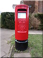
Post Box, Beaumont Drive, Whitley Bay
This Type K post box, which stands on Beaumont Drive next to the junction with Cranleigh Place, dates from the reign of Queen Elizabeth and was probably erected in the early 1970s. For a selection of detailed free to download walking routes in the area visit www.northtynesidewalks.co.uk
Image: © Geoff Holland
Taken: 12 Mar 2021
0.17 miles
6
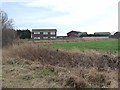
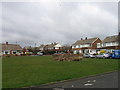
Urban fringe
Houses on Beaumont Drive, Whitley Bay, backing onto open fields.
Image: © Oliver Dixon
Taken: 23 Feb 2012
0.20 miles
7
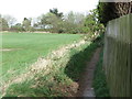
Footpath adjoining Beaumont Park Housing Estate, Whitley Bay
This footpath is not shown on the current Ordnance Survey 1:25K map of the area nor is it a designated public footpath. It extends from a point just next to the kissing gate shown at https://www.geograph.org.uk/photo/6443234 to the course of the old Avenue Branch of the Blyth & Tyne Railway, now designated as a 'traffic-free cycle route'. For a selection of detailed free to download walking routes in the area visit www.northtynesidewalks.co.uk
Image: © Geoff Holland
Taken: 14 Apr 2020
0.21 miles
8
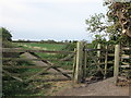
Kissing Gate at Beaumont Park Housing Estate, Whitley Bay
This kissing gate gives access to and egress from the public footpath shown at https://www.geograph.org.uk/photo/6443194, which links Beaumont Park housing estate with the course of the old Avenue Branch of the Blyth & Tyne Railway, now designated as a 'traffic-free cycle route'. For a selection of detailed free to download walking routes in the area visit www.northtynesidewalks.co.uk
Image: © Geoff Holland
Taken: 14 Apr 2020
0.21 miles
10
Waggonways Cycle Track
This cycle track has adopted the old Avenue Branch Line that ran from Whitley Bay to the A190 Seaton Delaval to Seaton Sluice.
Image: © Chris Heaton
Taken: 23 Jul 2008
0.22 miles