IMAGES TAKEN NEAR TO
Earsdon Road, WHITLEY BAY, NE25 9SU
Introduction
This page details the photographs taken nearby to Earsdon Road, NE25 9SU by members of the Geograph project.
The Geograph project started in 2005 with the aim of publishing, organising and preserving representative images for every square kilometre of Great Britain, Ireland and the Isle of Man.

There are currently over 7.5m images from over14,400 individuals and you can help contribute to the project by visiting https://www.geograph.org.uk
Image Map (Loading...)


Getting Data...Please wait
Leaflet Map data © OpenStreetMap
Images are licensed for reuse under creativecommons.org/licenses/by-sa/2.0
Notes
- Clicking on the map will re-center to the selected point.
- The higher the marker number, the further away the image location is from the centre of the postcode.
Image Listing (35 Images Found)
Images are licensed for reuse under creativecommons.org/licenses/by-sa/2.0
Image
Details
Distance
1
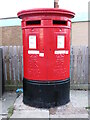
Post Box, Earsdon Road, West Monkseaton
This dual aperture post box stands in front of what was, until 2016, West Monkseaton Post Office. This box dates from the reign of Elizabeth II although dual aperture boxes first appeared in 1899. They were designated Type C boxes and were first introduced in London to help pre-sort mail into 'London and Abroad' and 'Country'. The Royal Mail is a key partner in the Government's Coronavirus testing programme and collect completed testing kits from over 35,000 specially selected post boxes of which this is one (see stickers attached to the box). For a selection of detailed free to download walking routes in the area visit www.northtynesidewalks.co.uk
Image: © Geoff Holland
Taken: 18 Jan 2021
0.03 miles
3
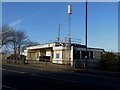
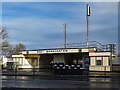
West Monkseaton Metro Station
The entrance building to the Tyne and Wear Metro station of West Monkseaton. The roof of the station has a couple of communication masts mounted on it.
Image: © Graham Robson
Taken: 24 Feb 2018
0.08 miles
4
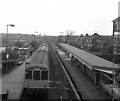
West Monkseaton station
In May 1979 the writing was already on the wall for British Railways diesel trains on this line, for the electric wires for the Metro trains that would replace them were already in place. This photograph shows a 3-car diesel about to depart for the Coast.
Image: © Dr Neil Clifton
Taken: 30 May 1979
0.09 miles
5
West Monkseaton Metro Station
West Monkseaton Metro station is a station on the Yellow line of the Tyne and Wear Metro. It is located in a residential area at the west of Monkseaton, with the station entrance sited above the tracks on Earsdon Road. The reinforced concrete Art-Deco station building at street level dates from 1934 when it was a station on the London & North Eastern Railway. The station reopened on the first phase of the Tyne & Wear Metro in 1980 and the building restored in 1999.
Disused Stations: http://www.disused-stations.org.uk/w/west_monkseaton/index.shtml
Image: © Andrew Curtis
Taken: 18 Jan 2018
0.09 miles
6
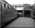
West Monkseaton station
At this time, diesel trains operated the service. Later it became part of Metro.
Image: © Dr Neil Clifton
Taken: 30 May 1979
0.09 miles
7

West Monkseaton Metro station, Tyne & Wear
Opened in 1933 by the London & North Eastern Railway on the North Tyneside loop line from Newcastle to Tynemouth, this station was converted to Metro operation in 1980.
View south west towards Shiremoor and Newcastle.
Image: © Nigel Thompson
Taken: 17 Sep 2010
0.09 miles

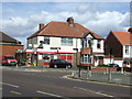
9
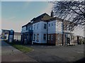
The Hunting Lodge, West Monkseaton
A large public house on Earsdon Road in West Monkseaton.
Image: © Graham Robson
Taken: 24 Feb 2018
0.09 miles
10
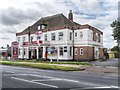
Hunting Lodge, West Monkseaton
Large public house on Earsdon Road.
Image: © David Dixon
Taken: 23 Jun 2014
0.09 miles