IMAGES TAKEN NEAR TO
Stobswood Close, WHITLEY BAY, NE25 9GA
Introduction
This page details the photographs taken nearby to Stobswood Close, NE25 9GA by members of the Geograph project.
The Geograph project started in 2005 with the aim of publishing, organising and preserving representative images for every square kilometre of Great Britain, Ireland and the Isle of Man.

There are currently over 7.5m images from over14,400 individuals and you can help contribute to the project by visiting https://www.geograph.org.uk
Image Map (Loading...)


Getting Data...Please wait
Leaflet Map data © OpenStreetMap
Images are licensed for reuse under creativecommons.org/licenses/by-sa/2.0
Notes
- Clicking on the map will re-center to the selected point.
- The higher the marker number, the further away the image location is from the centre of the postcode.
Image Listing (13 Images Found)
Images are licensed for reuse under creativecommons.org/licenses/by-sa/2.0
Image
Details
Distance
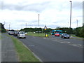
1
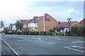
Show homes on Coanwood Drive, West Monkseaton
Show homes built by Taylor Wimpey as part of their West Park development on the edge of West Monkseaton. The new road has been given the name Coanwood Drive.
Image: © Graham Robson
Taken: 24 Nov 2018
0.03 miles
2
Coanwood Drive, West Monkseaton
The main access road into to a new residential development being built by Taylor Wimpey.
Image: © Graham Robson
Taken: 24 Nov 2018
0.05 miles
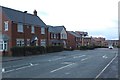
3
New houses, West Park, Monkseaton
A row of newly built homes fronting onto a public space within the development constructed by Taylor Wimpey.
Image: © Graham Robson
Taken: 24 Nov 2018
0.06 miles
4
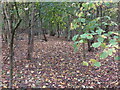
Woodland near Earsdon Road, Whitley Bay
This woodland was planted many years ago by North Tyneside Council in anticipation of the future development for housing of the land immediately to the north east. It acts as a buffer zone between the busy Earsdon Road and the now established housing estate. For a selection of detailed free to download walking routes in the area visit www.northtynesidewalks.co.uk
Image: © Geoff Holland
Taken: 27 Oct 2020
0.09 miles
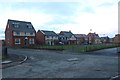
5
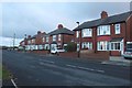
Hesleyside Road, West Monkseaton
Semi-detached houses on the edge of the housing estate of South Wellfield.
Image: © Graham Robson
Taken: 24 Nov 2018
0.14 miles
6

Footpath, Beaumont Park, Whitley Bay
This footpath cuts through a 'green' buffer zone separating different sections of this large housing estate. On the left hand side, beyond the fence and the tangle of undergrowth lies a small pond. For a selection of detailed free to download walking routes in the area visit www.northtynesidesidewalks.co.uk
Image: © Geoff Holland
Taken: 27 Oct 2020
0.15 miles
8
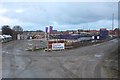
Construction site, Wellfield
One of the later phases of house construction on the West Park development by Taylor Wimpey. The houses in the background are already complete and occupied.
Image: © Graham Robson
Taken: 24 Nov 2018
0.21 miles
9

Sainsbury's Whitley Bay
This is in Monkseaton rather than Whitley Bay.
Image: © Bill Boaden
Taken: 16 Sep 2011
0.22 miles
10

The Beacon Public House, West Monkseaton
An upmarket pub just up the road from Sainsbury's!
Image: © Alan Fearon
Taken: 14 Nov 2005
0.24 miles