IMAGES TAKEN NEAR TO
Kensington Close, CRAMLINGTON, NE23 7UG
Introduction
This page details the photographs taken nearby to Kensington Close, NE23 7UG by members of the Geograph project.
The Geograph project started in 2005 with the aim of publishing, organising and preserving representative images for every square kilometre of Great Britain, Ireland and the Isle of Man.

There are currently over 7.5m images from over14,400 individuals and you can help contribute to the project by visiting https://www.geograph.org.uk
Image Map
Images are licensed for reuse under creativecommons.org/licenses/by-sa/2.0
Notes
- Clicking on the map will re-center to the selected point.
- The higher the marker number, the further away the image location is from the centre of the postcode.
Image Listing (30 Images Found)
Images are licensed for reuse under creativecommons.org/licenses/by-sa/2.0
Image
Details
Distance
1
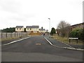
Kensington Close, Seghill
A development of half a dozen new houses on the edge of Seghill.
Image: © Graham Robson
Taken: 13 Jan 2018
0.04 miles
2

Modern building at Atkinson House School, Seghill
Atkinson House School caters for children with emotional, social and mental health issues. The building pictured here was opened in 2010.
Image: © Graham Robson
Taken: 13 Jan 2018
0.09 miles
3
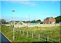
Former Seghill Colliery pit yard
The mine closed in 1962. This is now a small industrial area. Some of the original pit buildings remain, supplemented by an assortment of more recent buildings.
The mine was mentioned in the old folk song 'Blackleg Miner':
'Dinna gang near the Seghill mine.
Across the way they stretch a line,
To catch the throat and break the spine
Of the dirty blackleg miner.'
Image: © Antony Dixon
Taken: 14 Sep 2012
0.13 miles
4
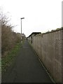
Footpath, Seghill
A footpath between housing estates in Seghill. The path is on an embankment above the level of the surrounding properties on the alignment of an old railway line which connected the nearby mineral railway to the East Coast Mainline.
Image: © Graham Robson
Taken: 13 Jan 2018
0.15 miles
5
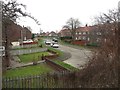
Blaketown, Seghill
A residential street close to the centre of the village.
Image: © Graham Robson
Taken: 13 Jan 2018
0.17 miles
6
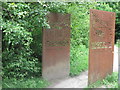
No Entry Gates Artwork Near Middle Farm, Seghill
This artwork by artist Simon Ringe straddles the track which runs between the railway crossing shown at https://www.geograph.org.uk/photo/6524310 and Middle farm, and make a pleasant interlude when passing this way. For a selection of detailed free to download walking routes in the area visit www.northtynesidewalks.co.uk
Image: © Geoff Holland
Taken: 30 Jun 2020
0.17 miles
7
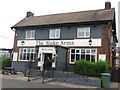
The Blake Arms, Seghill
This public house has undergone a bit of a makeover since Christine Westerback visited here back in 2005 https://www.geograph.org.uk/photo/36031. For a selection of detailed free to download walking routes in the area visit www.northtynesidewalks.co.uk
Image: © Geoff Holland
Taken: 30 Jun 2020
0.18 miles
8
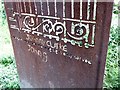
"The gates with their warning signs only served..."
Close-up of one leaf of the gates seen in Image See also Image Pity about the almost inevitable graffiti.
Image: © Oliver Dixon
Taken: 20 Jul 2020
0.18 miles
9
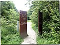
"Keep out - No entry - Trespassers will be prosecuted"
An improbable threat. Unlike Image which will allegedly never open until a Stuart King once more sits on the throne of England, these gates will never close. A sculpture created by Simon Ridge forming part of an art trail funded by the National Lottery. It stands on a path which follows an old waggonway.
Image: © Oliver Dixon
Taken: 20 Jul 2020
0.18 miles
10
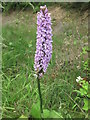
Common Spotted-Orchid Near Middle Farm, Seghill
The Common Spotted-Orchid is the most common of all UK orchids and it grows in many different habitats, including woodland, roadside verges, hedgerows, old quarries, sand dunes and marshes. It can grow up to 60 cm. and this fine specimen was very close to that height. For a selection of detailed free to download walking routes in the area visit www.northtynesidewalks.co.uk
Image: © Geoff Holland
Taken: 30 Jun 2020
0.18 miles