IMAGES TAKEN NEAR TO
Eastwood Close, CRAMLINGTON, NE23 7LF
Introduction
This page details the photographs taken nearby to Eastwood Close, NE23 7LF by members of the Geograph project.
The Geograph project started in 2005 with the aim of publishing, organising and preserving representative images for every square kilometre of Great Britain, Ireland and the Isle of Man.

There are currently over 7.5m images from over14,400 individuals and you can help contribute to the project by visiting https://www.geograph.org.uk
Image Map
Images are licensed for reuse under creativecommons.org/licenses/by-sa/2.0
Notes
- Clicking on the map will re-center to the selected point.
- The higher the marker number, the further away the image location is from the centre of the postcode.
Image Listing (17 Images Found)
Images are licensed for reuse under creativecommons.org/licenses/by-sa/2.0
Image
Details
Distance
1
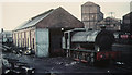
Burradon NCB shed, shortly before closure.
Image: © Roger Cornfoot
Taken: Unknown
0.04 miles
2
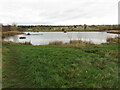
Pond, Burradon
This pond lies on an area of land once occupied by Burradon Colliery. The colliery was sunk in the 1820s along with a waggonway running from the colliery to Killingworth Colliery to the south. From there the coal from Burradon Colliery continued its journey along waggonways to the River Tyne. On the 2nd March 1860, an explosion at Burradon Colliery killed 76 men and boys and the disaster took on national significance at a time when mining safety was poor and the families of disaster victims had to rely on charity. The colliery eventually closed on the 22nd November 1975. For a selection of detailed free to download walking routes in the area visit www.northtynesidewalks.co.uk
Image: © Geoff Holland
Taken: 17 Nov 2020
0.05 miles
4
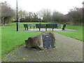
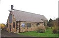
Fryer's Millennium Green, Burradon
When the second edition of the Ordnance Survey Six-Inch map of the area was published in 1898 this area was the site of Fryer's Terrace. Subsequently, in 1954, the properties in Fryer's Terrace were demolished and the area became derelict for many years. The project to create the Millennium Green was organised by the Burradon & Camperdown Forum and was officially opened in 2001. The land is now owned and maintained by North Tyneside Council. For a selection of detailed free to download walking routes in the area visit www.northtynesidewalks.co.uk
Image: © Geoff Holland
Taken: 17 Nov 2020
0.14 miles
5
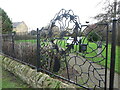
Decorative Railings, Fryer's Millennium Green, Burradon
When the second edition of the Ordnance Survey Six-Inch map of the area was published in 1898 this area was the site of Fryer's Terrace. Subsequently, in 1954, the properties in Fryer's Terrace were demolished and the area became derelict for many years. The project to create the Millennium Green was organised by the Burradon & Camperdown Forum and was officially opened in 2001. These railings lie on the western boundary of the Millennium Green. The land is now owned and maintained by North Tyneside Council. For a selection of detailed free to download walking routes in the area visit.
Image: © Geoff Holland
Taken: 17 Nov 2020
0.14 miles
6
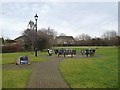
Fryers Millennium Green, Burradon
A crossing of Burradon Road, B1505 near the centre of Burradon. To the left is Fryers Millennium Green, a urban renewal scheme which was approved by the Countryside Commission as a Millennium Green and was opened in 2001. The benches are her covered with floral tributes to a local resident who died at the end of 2011.
Image: © Oliver Dixon
Taken: 23 Feb 2012
0.15 miles
7
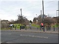
Burradon village
A crossing of Burradon Road, B1505 near the centre of Burradon. To the left is Fryers Millennium Green, a urban renewal scheme which was approved by the Countryside Commission as a Millennium Green and was opened in 2001.
Straight ahead is the line of the Burradon and Holywell Waggonway. This was one of many waggonways http://www.tynelives.org.uk/stephenson/wagmap2.htm linking former coalmines in North Tyneside with the coal staithes on the Tyne. Along with many other lengths of waggonway, this section has been converted into a cycle path in recent years and this section forms part of National Cycle Network, Regional Route 10 (the Reivers Cycle Route) http://www.cycle-n-sleep.co.uk/rinfo/map%20reivers.htm which links Tynemouth with Whitehaven via Kielder Forest and Carlisle. Ironwork street furniture, such as the barrier, is a common feature found on the restored paths.
Image: © Oliver Dixon
Taken: 23 Feb 2012
0.16 miles
8
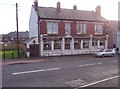
Grey Horse Inn
A traditional pub in Burradon.
Image: © Weston Beggard
Taken: 5 Nov 2005
0.17 miles
9
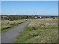
Burradon Colliery site
The mineral railway here was shown as a solid black line symbol railway on the 1976 1:50,000 map and as a disused mineral line in 1981.
Image: © Richard Webb
Taken: 1 Oct 2015
0.17 miles