IMAGES TAKEN NEAR TO
The Grange, Middle Farm, CRAMLINGTON, NE23 7DH
Introduction
This page details the photographs taken nearby to The Grange, Middle Farm, NE23 7DH by members of the Geograph project.
The Geograph project started in 2005 with the aim of publishing, organising and preserving representative images for every square kilometre of Great Britain, Ireland and the Isle of Man.

There are currently over 7.5m images from over14,400 individuals and you can help contribute to the project by visiting https://www.geograph.org.uk
Image Map
Images are licensed for reuse under creativecommons.org/licenses/by-sa/2.0
Notes
- Clicking on the map will re-center to the selected point.
- The higher the marker number, the further away the image location is from the centre of the postcode.
Image Listing (38 Images Found)
Images are licensed for reuse under creativecommons.org/licenses/by-sa/2.0
Image
Details
Distance
1
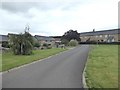
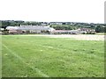
Housing at Middle Farm
Middle Farm is a cluster of farm buildings which have been converted to a number of desirable residences.
Image: © Oliver Dixon
Taken: 20 Jul 2020
0.01 miles
2
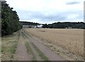
Bridleway to Middle Farm
The farmland to the north of Seghill is criss-crossed with bridleways, many of which coincide with the line of old waggonways. Middle Farm is a cluster of farm buildings which have been converted to a number of desirable residences.
Image: © Oliver Dixon
Taken: 20 Jul 2020
0.01 miles
3
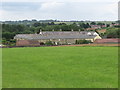
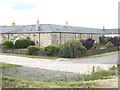
Middle Farm, Seghill
The configuration of Middle Farm has changed little since the first Ordnance Survey Six-Inch map of the area was published in 1865 although the surrounding area has undergone massive change. The area immediately behind Middle Farm was once the site of Seghill Colliery which closed in 1962. The properties within Middle Farm are now utilised as private dwellings, many of which have been converted from various farm outbuildings. For a selection of detailed free to download walking routes in the area visit www.northtynesidewalks.co.uk
Image: © Geoff Holland
Taken: 7 Jul 2020
0.02 miles
4
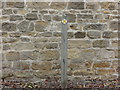
Public Footpath Marker Post, Middle Farm, Seghill
This inconspicuous marker post ensures that pedestrians pass through the housing development at Middle Farm without straying from the designated public footpath route. For a selection of detailed free to download walking routes in the area visit www.northtynesidewalks.co.uk
Image: © Geoff Holland
Taken: 7 Jul 2020
0.02 miles
5
Middle Farm
Middle Farm is a cluster of farm buildings which have been converted to a number of desirable residences.
Image: © Oliver Dixon
Taken: 20 Jul 2020
0.02 miles
6
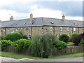
Middle Farm, Seghill
These two stone-built terraces form part of the sympathetic housing development at Middle Farm with many of the properties being converted from various farm outbuildings. For a selection of detailed free to download walking routes in the area visit www.northtynesidewalks.co.uk
Image: © Geoff Holland
Taken: 7 Jul 2020
0.02 miles
7
Housing at Middle Farm
Middle Farm is a cluster of farm buildings which have been converted to a number of desirable residences.
Image: © Oliver Dixon
Taken: 20 Jul 2020
0.02 miles
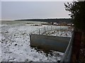
8
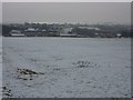
Middle Grange Farm
View of Middle Grange Farm from the soon to be re-routed public footpath at the top of the hill.
Image: © Ian Brackenridge
Taken: 24 Dec 2009
0.02 miles
9
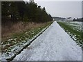
Middle Grange Farm
View East along the public footpath towards Middle Grange Farm, near Seghill/Seaton Delaval.
Image: © Ian Brackenridge
Taken: 24 Dec 2009
0.03 miles
10
Middle Grange Farm
View over the fields of Middle Grange Farm in Seaton Delaval/Seghill area.
Image: © Ian Brackenridge
Taken: 24 Dec 2009
0.04 miles