IMAGES TAKEN NEAR TO
Bedlington Bank, BEDLINGTON, NE22 5RY
Introduction
This page details the photographs taken nearby to Bedlington Bank, NE22 5RY by members of the Geograph project.
The Geograph project started in 2005 with the aim of publishing, organising and preserving representative images for every square kilometre of Great Britain, Ireland and the Isle of Man.

There are currently over 7.5m images from over14,400 individuals and you can help contribute to the project by visiting https://www.geograph.org.uk
Image Map
Images are licensed for reuse under creativecommons.org/licenses/by-sa/2.0
Notes
- Clicking on the map will re-center to the selected point.
- The higher the marker number, the further away the image location is from the centre of the postcode.
Image Listing (34 Images Found)
Images are licensed for reuse under creativecommons.org/licenses/by-sa/2.0
Image
Details
Distance
1
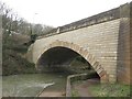
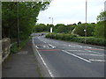
Bedlington Bridge
The bridge carries the A193 road across the River Blyth at the bottom of Bedlington Bank.
Image: © Graham Robson
Taken: 26 Feb 2017
0.03 miles
2
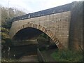
Bedlington Bridge
Originally constructed in 1928 the arch was part of modifications carried out in 1996.
Image: © Anthony Foster
Taken: 9 Nov 2020
0.03 miles
3
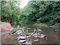
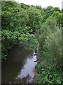
River Blyth, Bedlington Country Park
The River Blyth flows eastwards through southern Northumberland into the North Sea, and is 27 miles (44 km) long. At this point the river has just flowed beneath Bedlington Bridge https://www.geograph.org.uk/photo/7296811.
Image: © Geoff Holland
Taken: 27 Sep 2022
0.04 miles
4
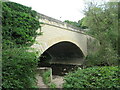
Bedlington Bridge, Bedlington
The original masonry bridge was replaced by a concrete slab and beam bridge in 1928, and in turn was modified when an arch was constructed in 1996.
Image: © Geoff Holland
Taken: 27 Sep 2022
0.04 miles
6
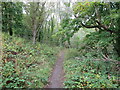
Public Bridleway near Bedlington Bridge, Bedlington
This public bridleway, which starts at Attlee Park https://www.geograph.org.uk/photo/7296800, follows the River Blyth downstream, to reach Furnace Bridge https://www.geograph.org.uk/photo/287924 and the site of the former Bedlington Iron Works after approximately 1 mile (1.58km).
Image: © Geoff Holland
Taken: 27 Sep 2022
0.05 miles
7
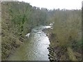
River Blyth
From Bedlington Bridge, looking upstream.
Image: © Russel Wills
Taken: 19 Feb 2016
0.06 miles
9

Bedlington Bridge, south east Northumberland
The bridge over the River Blyth. Just south and east of Bedlington town centre.
An extremely cold and frosty morning in January 2006.
Image: © Chris Tweedy
Taken: 31 Jan 2006
0.07 miles
10
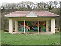
Bandstand, Attlee Park, Bedlington
The bandstand in Attlee Park dates from 1955 and was used as a stage for speeches during the Northumberland Miner's Picnic which was held here between the 1950s and 1992. The bandstand was refurbished in 2013.
Image: © Graham Robson
Taken: 26 Feb 2017
0.10 miles