IMAGES TAKEN NEAR TO
Merton Way, NEWCASTLE UPON TYNE, NE20 9PX
Introduction
This page details the photographs taken nearby to Merton Way, NE20 9PX by members of the Geograph project.
The Geograph project started in 2005 with the aim of publishing, organising and preserving representative images for every square kilometre of Great Britain, Ireland and the Isle of Man.

There are currently over 7.5m images from over14,400 individuals and you can help contribute to the project by visiting https://www.geograph.org.uk
Image Map
Images are licensed for reuse under creativecommons.org/licenses/by-sa/2.0
Notes
- Clicking on the map will re-center to the selected point.
- The higher the marker number, the further away the image location is from the centre of the postcode.
Image Listing (122 Images Found)
Images are licensed for reuse under creativecommons.org/licenses/by-sa/2.0
Image
Details
Distance
1
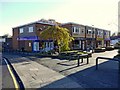
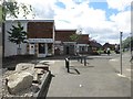
Ponteland Shopping Centre
A small pedestrianised area of local shops in Ponteland. Businesses include a few take-aways, a hardware shop and post office.
Image: © Graham Robson
Taken: 6 Aug 2016
0.02 miles
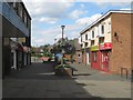
2
Ponteland Shopping Centre, Thornhill Road
Merton Way is to the right Image
Image: © Andrew Curtis
Taken: 6 Nov 2010
0.03 miles
3
Merton Way, Ponteland
A walkway leading to the Shopping Centre which was built on the former site of Ponteland Railway Station and Goods Yard Image The railway was built by the North Eastern Railway Company between 1904-05 running 7 miles from South Gosforth to Ponteland via Kenton Bank Foot. The section from the city to the airport is now part of the Metro network. The line to Ponteland was closed to regular passenger traffic in 1929 but casual use continued until 1967 when Richard Beeching instigated the National Rail Closures.
Ponteland had the largest goods yard on the line which was sited on the west side of the station. Facilities in 1920 included five sidings and a reversing loop, water tower, cattle dock and a large brick goods shed.
Disused Stations - Ponteland: http://www.disused-stations.org.uk/p/ponteland/index.shtml
Image: © Andrew Curtis
Taken: 24 Sep 2010
0.03 miles
4
Ponteland Shopping Centre
The small group of local shops in the centre of Ponteland.
Image: © Graham Robson
Taken: 6 Aug 2016
0.04 miles
5
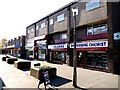
Ponteland Shopping Centre, Thornhill Road
This pedestrian lane between rows of shops is known as Merton Way. The shopping centre was built in the 1960s and plans are advanced for their replacement and regeneration of the whole area http://ponteland.journallive.co.uk/2009/02/ageing-ponteland-shopping-cent.html
Image: © Andrew Curtis
Taken: 6 Nov 2010
0.04 miles
6
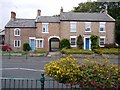
Two houses on the north side of Main Street
The houses are in Ponteland and face the Waitrose store there.
The centre section is unusual being presumably an addition to the left hand property - the brickwork is different. Also in that addition the upper floor window is raised, probably a necessity to accommodate the arch of the passage through to the rear.
Image: © Trevor Littlewood
Taken: 23 Aug 2019
0.04 miles
7
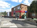
One Stop store, Ponteland
A branch of the One Stop stores chain in Ponteland town centre.
Image: © Graham Robson
Taken: 6 Aug 2016
0.04 miles
8
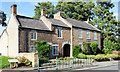
Former farmhouse and cottage, Main Street, Ponteland
The farmhouse and cottage were built in the C18th and early C19th http://www.keystothepast.info/article/10339/Site-Details?PRN=N11013
Image: © Andrew Curtis
Taken: 24 Sep 2010
0.04 miles
9
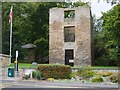
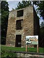
Vicar's Pele Tower, Ponteland
The Vicarage Tower or Vicar's Pele was built around 1400. Pele Towers were defensive buildings constructed to provide defence during the border raids. It was formerly the residence of the vicars of Ponteland and in the C18th was incorporated into a much larger vicarage complex. This was demolished in 1860 although the tower was left as a harness room. The tower was restored in 1971 and 2002.
Image: © Andrew Curtis
Taken: 24 Sep 2010
0.05 miles