IMAGES TAKEN NEAR TO
Cheviot View, NEWCASTLE UPON TYNE, NE20 9BH
Introduction
This page details the photographs taken nearby to Cheviot View, NE20 9BH by members of the Geograph project.
The Geograph project started in 2005 with the aim of publishing, organising and preserving representative images for every square kilometre of Great Britain, Ireland and the Isle of Man.

There are currently over 7.5m images from over14,400 individuals and you can help contribute to the project by visiting https://www.geograph.org.uk
Image Map
Images are licensed for reuse under creativecommons.org/licenses/by-sa/2.0
Notes
- Clicking on the map will re-center to the selected point.
- The higher the marker number, the further away the image location is from the centre of the postcode.
Image Listing (7 Images Found)
Images are licensed for reuse under creativecommons.org/licenses/by-sa/2.0
Image
Details
Distance
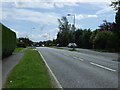
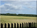
2
Cheviot View, near Ponteland
A view of the back of this small housing estate built along the A696 to Ponteland, taken from the old railway path.
Image: © Alan Fearon
Taken: 9 Dec 2005
0.05 miles
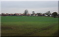
3
Houses at Cheviot View
Cheviot View is a settlement, a housing estate really, along the line of the A696 between Ponteland and Newcastle Airport.
Image: © Trevor Littlewood
Taken: 23 Aug 2019
0.05 miles
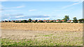
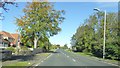
4
Ridgely Drive
Housing area to the southeast of Ponteland, on a stormy day in mid-September (note the turbulence in the trees to the left).
Image: © Barbara Carr
Taken: 15 Sep 2013
0.10 miles
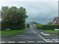
7
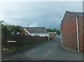
Clickemin, Ponteland
This is a curious name - the closest I can find is Clickhimin (several places in Scotland), which is said to come from Old Norse: 'klakk' meaning 'rock, and 'minni' meaning 'mouth'. Ponteland is generally accepted to mean 'island in the {river} Pont', so perhaps Clickemin originally stood at the rocky mouth of a tributary of the Pont.
Image: © Barbara Carr
Taken: 15 Sep 2013
0.18 miles