IMAGES TAKEN NEAR TO
Belsay, NEWCASTLE UPON TYNE, NE20 0HF
Introduction
This page details the photographs taken nearby to NE20 0HF by members of the Geograph project.
The Geograph project started in 2005 with the aim of publishing, organising and preserving representative images for every square kilometre of Great Britain, Ireland and the Isle of Man.

There are currently over 7.5m images from over14,400 individuals and you can help contribute to the project by visiting https://www.geograph.org.uk
Image Map
Images are licensed for reuse under creativecommons.org/licenses/by-sa/2.0
Notes
- Clicking on the map will re-center to the selected point.
- The higher the marker number, the further away the image location is from the centre of the postcode.
Image Listing (16 Images Found)
Images are licensed for reuse under creativecommons.org/licenses/by-sa/2.0
Image
Details
Distance
1
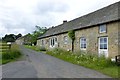
Sundial House, Harnham
Sundial House stands towards the east of the hamlet of Harnham. The central part of the building is a two floored block. A smaller cottage is built onto the west end, and a separate house joins the east end. The body of the main house is built of rubble, and the walls are 0.8m thick. Although parts of the house, such as the southern front, probably date to the 19th century, it was probably built in the 15th or 16th century. It is similar in form to a bastle, a fortified farmhouse. Old references to a Middle Stone House at Harnham may refer to this house. This is a Grade II Listed Building protected by law.
http://www.keystothepast.info/durhamcc/K2P.nsf/K2PDetail?readform&PRN=N10622
Image: © Les Hull
Taken: 15 Dec 2010
0.01 miles

3
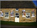
Buddhist Monastery
Colourful Banners decorate the exterior of the Monastery at Harnam.
Image: © Bill Cresswell
Taken: 13 Oct 2006
0.04 miles
4
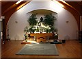
The 'Aruna Natanagiri' Buddhist Monastery
The monastery at Harnham.
Image: © Bill Cresswell
Taken: 13 Oct 2006
0.04 miles
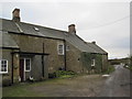
6
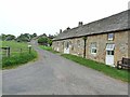
Cottages at Harnham
Hamlet off the A696.
Image: © Oliver Dixon
Taken: 29 May 2012
0.08 miles
7
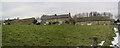
Harnham
The single storey building on the right are now a Buddhist Monestery
http://www.ratanagiri.org.uk/
Originally they were "Byre and barn to East of No. 2, Harnham "
These agricultural buildings date to the 18th century; a lintel bears the initials T.L. and the date 1786. The letters refer to a member of the Leighton family - this family owned the area from 1702. This is a Grade II Listed Building protected by law.
http://www.keystothepast.info/durhamcc/K2P.nsf/K2PDetail?readform&PRN=N21048
Image: © Les Hull
Taken: 15 Dec 2010
0.08 miles
8
Buddhist Monastery at Harnam
In what were Harnham Hall Cottages.
https://ratanagiri.org.uk/
Image: © Russel Wills
Taken: 30 Jun 2016
0.08 miles
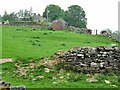
9
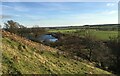
Spectacular drystone wall
This stone wall has been magnificently restored- see earlier photos of it. To cope with the approx 30° gradient the 'courses' are laid horizontally and the capstones vertically. Fine job. Harnham reservoir in the distance.
Image: © Leanmeanmo
Taken: 16 Dec 2021
0.10 miles
