IMAGES TAKEN NEAR TO
Moor Close, NE16 6DE
Introduction
This page details the photographs taken nearby to Moor Close, NE16 6DE by members of the Geograph project.
The Geograph project started in 2005 with the aim of publishing, organising and preserving representative images for every square kilometre of Great Britain, Ireland and the Isle of Man.

There are currently over 7.5m images from over14,400 individuals and you can help contribute to the project by visiting https://www.geograph.org.uk
Image Map
Images are licensed for reuse under creativecommons.org/licenses/by-sa/2.0
Notes
- Clicking on the map will re-center to the selected point.
- The higher the marker number, the further away the image location is from the centre of the postcode.
Image Listing (7 Images Found)
Images are licensed for reuse under creativecommons.org/licenses/by-sa/2.0
Image
Details
Distance
1

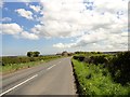
Trees beside Barcusclose Lane
View looking north from the roadside. This country road leads from Crookgate to Tanfield, through some lovely countryside.
Image: © Robert Graham
Taken: 14 May 2014
0.08 miles
2
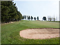
Fairway with sand trap
Part of the Hobson Golf Course which lies to the north of the village of Tanfield.
Image: © Trevor Littlewood
Taken: 18 Apr 2019
0.12 miles
3
View along Barcusclose Lane
Looking east towards New Low Barcus Close Farm. The lane runs past here to Tanfield village.
Image: © Robert Graham
Taken: 14 May 2014
0.15 miles
4
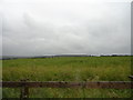
View from Barcushouse Lane
Looking SW from opposite the farm, with Tantobie on the horizon.
Image: © Robert Graham
Taken: 11 Jul 2012
0.18 miles

6
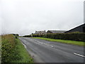
Farm on Barcusclose Lane
This lane leads north from Tanfield Village to Crookgate.
Image: © Robert Graham
Taken: 11 Jul 2012
0.19 miles
7
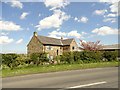
New Low Barcus Close farmhouse
This farm stands on Barcusclose Lane, which runs east from Crookgate to Tanfield village. It's not the farm that the lane is named after; that stood a short way west along the lane and was demolished in the 1990's. The original, C19, Low Barcus was destroyed by fire in 1973 and this farm was built to replace it shortly afterwards. It was built in stone in a traditional manner and looks older than it actually is.
Image: © Robert Graham
Taken: 14 May 2014
0.19 miles