IMAGES TAKEN NEAR TO
Kingsway, NEWCASTLE UPON TYNE, NE16 5PH
Introduction
This page details the photographs taken nearby to Kingsway, NE16 5PH by members of the Geograph project.
The Geograph project started in 2005 with the aim of publishing, organising and preserving representative images for every square kilometre of Great Britain, Ireland and the Isle of Man.

There are currently over 7.5m images from over14,400 individuals and you can help contribute to the project by visiting https://www.geograph.org.uk
Image Map
Images are licensed for reuse under creativecommons.org/licenses/by-sa/2.0
Notes
- Clicking on the map will re-center to the selected point.
- The higher the marker number, the further away the image location is from the centre of the postcode.
Image Listing (19 Images Found)
Images are licensed for reuse under creativecommons.org/licenses/by-sa/2.0
Image
Details
Distance
1
Sunniside Railway Station
A derelict railway station at the end of the Tanfield Light Railway. The railway does say that the current timetable includes Sunniside on its current timetable.
Image: © Steve McShane
Taken: 29 Oct 2005
0.10 miles
2
Sun Street, Sunniside
The view down the A692 in the centre of Sunniside.
Image: © Steve McShane
Taken: 29 Oct 2005
0.10 miles
3
Traffic refuge on Lobley Hill Road
To facilitate crossing this busy road for pedestrians and cyclists.
Image: © Oliver Dixon
Taken: 29 Jul 2020
0.16 miles
5
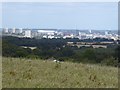
View from the hill above Sunniside
Looking over the Tyne towards the dreaming spires of Newcastle. St James' Stadium Image, home of Newcastle United Football Club can be clearly seen towards the left. Briefly in 2011-12, the Stadium was renamed the "Sport Direct" Stadium.
Image: © Oliver Dixon
Taken: 29 Jul 2020
0.18 miles
6
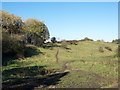
Rough grazing north of Marley Hill
Marley Hill is a small village, now part of Gateshead; the roughly grassed area lies to the west of the A692 connecting it with Sunniside, another village of Gateshead.
Image: © Trevor Littlewood
Taken: 2 Nov 2015
0.19 miles
9
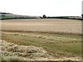
Field of wheat at Riding Barns Farm
The combine harvester in Image can be seen at the far end of the field.
Image: © Oliver Dixon
Taken: 29 Jul 2020
0.19 miles
10
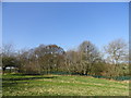
Rookery at the Vicarage
Rookery at Marley Hill. Although most rookeries are of long standing, this one isn't. The birds established it only about 10 years ago, I believe.
Image: © Robert Graham
Taken: 27 Mar 2012
0.22 miles