IMAGES TAKEN NEAR TO
St. Cuthberts Road, NEWCASTLE UPON TYNE, NE16 5EB
Introduction
This page details the photographs taken nearby to St. Cuthberts Road, NE16 5EB by members of the Geograph project.
The Geograph project started in 2005 with the aim of publishing, organising and preserving representative images for every square kilometre of Great Britain, Ireland and the Isle of Man.

There are currently over 7.5m images from over14,400 individuals and you can help contribute to the project by visiting https://www.geograph.org.uk
Image Map
Images are licensed for reuse under creativecommons.org/licenses/by-sa/2.0
Notes
- Clicking on the map will re-center to the selected point.
- The higher the marker number, the further away the image location is from the centre of the postcode.
Image Listing (14 Images Found)
Images are licensed for reuse under creativecommons.org/licenses/by-sa/2.0
Image
Details
Distance
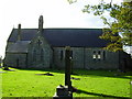
2
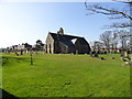
Village Church
St Cuthbert's Church at Marley Hill, a small village just south of Sunniside.
Image: © Robert Graham
Taken: 27 Mar 2012
0.04 miles
3
New houses in Marley Hill
Taken from an open window on a Tanfield Railway train.
Image: © Christine Johnstone
Taken: 25 Jul 2010
0.05 miles
4
Rookery at the Vicarage
Rookery at Marley Hill. Although most rookeries are of long standing, this one isn't. The birds established it only about 10 years ago, I believe.
Image: © Robert Graham
Taken: 27 Mar 2012
0.15 miles
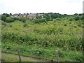
5
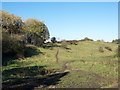
Rough grazing north of Marley Hill
Marley Hill is a small village, now part of Gateshead; the roughly grassed area lies to the west of the A692 connecting it with Sunniside, another village of Gateshead.
Image: © Trevor Littlewood
Taken: 2 Nov 2015
0.16 miles
6
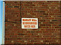
Sign on gable end, Marley Hill
Terraced housing neighbourhood watch area. Typical brick building in this area.
Image: © wfmillar
Taken: 22 Jul 2008
0.17 miles
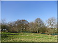
7
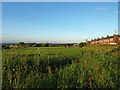
Playing fields, Marley Hill
The brick terraced housing of Marley Hill to the right.
Image: © wfmillar
Taken: 22 Jul 2008
0.18 miles
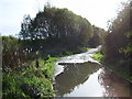
8
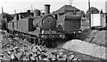
LNER 0-6-2Ts at Bowes Bridge, Marley Hill, 1954
View northward on the Stanhope & Tyne system near its junction with the Tanfield Railway. The locomotives are ex-NER Wilson Worsdell U class, LNER N10 0-6-2Ts: No. 89 of 12/1902, 1946 No. 9095, withdrawn as 69095 in 10/55, and No. 1716 of 4/1903, 1946 No. 9109, withdrawn as 69109 in 4/62.
Image: © Walter Dendy, deceased
Taken: 30 May 1954
0.18 miles
9
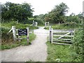
Fill in the missing letters
"__NFIELD _AILWA_ __WAR_ OF THE _RAINS"
Footpath crossing of the Tanfield Railway.
Image: © Oliver Dixon
Taken: 29 Jul 2020
0.18 miles
10
Track leading to the site of former Marley Hill Colliery
Image: © P Glenwright
Taken: 22 Oct 2006
0.19 miles