IMAGES TAKEN NEAR TO
Whaggs Lane, NEWCASTLE UPON TYNE, NE16 4PW
Introduction
This page details the photographs taken nearby to Whaggs Lane, NE16 4PW by members of the Geograph project.
The Geograph project started in 2005 with the aim of publishing, organising and preserving representative images for every square kilometre of Great Britain, Ireland and the Isle of Man.

There are currently over 7.5m images from over14,400 individuals and you can help contribute to the project by visiting https://www.geograph.org.uk
Image Map (Loading...)


Getting Data...Please wait
Leaflet Map data © OpenStreetMap
Images are licensed for reuse under creativecommons.org/licenses/by-sa/2.0
Notes
- Clicking on the map will re-center to the selected point.
- The higher the marker number, the further away the image location is from the centre of the postcode.
Image Listing (5 Images Found)
Images are licensed for reuse under creativecommons.org/licenses/by-sa/2.0
Image
Details
Distance
1
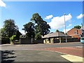
Top of Broom Lane, Whickham
The junction of the south end of Broom Lane with Whagg's Lane, the main route out of Whickham to the south. The trees here once held a Rookery, but no more.
Image: © Robert Graham
Taken: 8 Aug 2012
0.11 miles
2
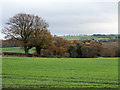
Field on outskirts of Whickham
The field is in the angle between Broom Lane and the B6316, Sunniside Road. The trees beyond are on a slope descending to the Black Burn.
Image: © Trevor Littlewood
Taken: 21 Nov 2017
0.17 miles
4
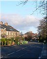
Looking east from Sunniside Road
Marshall Lands Farm in the middle distance and Gateshead on the far horizon.
Image: © Robert Graham
Taken: 8 Aug 2012
0.20 miles
5
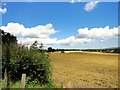
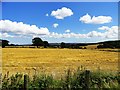
Harvesting beside the Sunniside road
Harvesting in progress along Sunniside Lane which runs south from Whickham to Sunniside.
Image: © Robert Graham
Taken: 8 Aug 2012
0.24 miles