IMAGES TAKEN NEAR TO
Lamedon Mill Court, NEWCASTLE UPON TYNE, NE15 8XS
Introduction
This page details the photographs taken nearby to Lamedon Mill Court, NE15 8XS by members of the Geograph project.
The Geograph project started in 2005 with the aim of publishing, organising and preserving representative images for every square kilometre of Great Britain, Ireland and the Isle of Man.

There are currently over 7.5m images from over14,400 individuals and you can help contribute to the project by visiting https://www.geograph.org.uk
Image Map
Images are licensed for reuse under creativecommons.org/licenses/by-sa/2.0
Notes
- Clicking on the map will re-center to the selected point.
- The higher the marker number, the further away the image location is from the centre of the postcode.
Image Listing (17 Images Found)
Images are licensed for reuse under creativecommons.org/licenses/by-sa/2.0
Image
Details
Distance
1

Lamedon Mill Court, Lemington
Lemington, Bell’s Close and Sugley were adjacent villages which developed in the nineteenth century around the new industries which took advantage of the coal and clay deposits as well as the nearby water transport on the River Tyne.
They were all part of the parish of Sugley. In the sixteenth century there was a Lamedon Mill and a Lamedon House and in 1638 the staithes at Lemendon are recorded. There was also a brickyard, tileshed, blacking factory and boatyard at Bell’s Close at this time.
Image: © Andrew Curtis
Taken: 11 Jul 2020
0.01 miles

3

Hadrian's Way and Lemington Road
Hadrian's Way, a path from Wylam to Newcastle along the north bank of the Tyne, carries both Hadrian's Cycleway
http://www.cycle-routes.org/HADRIANSCYCLEWAY/and Hadrian's Wall National
Trail http://www.nationaltrail.co.uk/hadrianswall/. The main road alongside is Lemington Road, A6085. On the far side of the road is a giant electricity sub-station.
Image: © Oliver Dixon
Taken: 8 Nov 2008
0.18 miles
4

Percy Pit Local Nature Reserve
View towards Lemington and the electricity substation Image and industrial estate south of Lemington Road. The Lemington Glassworks cone Image is clearly visible, a memorial to the past industry of this area http://www.nandnsociety.org.uk/City%20and%20County/nov08_lemington.htm
Image: © Andrew Curtis
Taken: 23 Jul 2010
0.18 miles

6
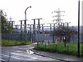
Electricity sub-station on Lemington Road
This giant sub-station stands near the site of the former Stella Power Station (now demolished). The road in the foreground is Lemington Road, A6085. Seen from Hadrian's Way, a path from Wylam to Newcastle along the north bank of the Tyne which carries both Hadrian's Cycleway
http://www.cycle-routes.org/HADRIANSCYCLEWAY/and Hadrian's Wall National Trail http://www.nationaltrail.co.uk/hadrianswall/.
Image: © Oliver Dixon
Taken: 8 Nov 2008
0.19 miles
7

Lemington Road (A6085)
Heading towards Blaydon.
Image: © JThomas
Taken: 2 May 2013
0.20 miles


10
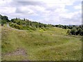
Percy Pit Local Nature Reserve
Percy Pit lies between Newburn and Lemington. Much of the site is grassland, some cut short for recreational use, the remainder left long to encourage wildlife. Hadrians' Way, the walkway/cycleway runs along the southern boundary of Percy Pit just above the road. It was designated as a Site of Nature Conservation Importance (SNCI) due to its grassland butterflies which include the Dingy Skipper.
Image: © Andrew Curtis
Taken: 23 Jul 2010
0.21 miles