IMAGES TAKEN NEAR TO
Bells Close Industrial Estate, NEWCASTLE UPON TYNE, NE15 6UF
Introduction
This page details the photographs taken nearby to Bells Close Industrial Estate, NE15 6UF by members of the Geograph project.
The Geograph project started in 2005 with the aim of publishing, organising and preserving representative images for every square kilometre of Great Britain, Ireland and the Isle of Man.

There are currently over 7.5m images from over14,400 individuals and you can help contribute to the project by visiting https://www.geograph.org.uk
Image Map (Loading...)


Getting Data...Please wait
Leaflet Map data © OpenStreetMap
Images are licensed for reuse under creativecommons.org/licenses/by-sa/2.0
Notes
- Clicking on the map will re-center to the selected point.
- The higher the marker number, the further away the image location is from the centre of the postcode.
Image Listing (67 Images Found)
Images are licensed for reuse under creativecommons.org/licenses/by-sa/2.0
Image
Details
Distance
1
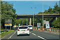
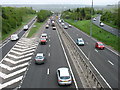
Blaydon : A1
Looking north along the A1.
Image: © Lewis Clarke
Taken: 21 Sep 2020
0.04 miles
3
Slow traffic on the A1
The Newcastle Western By-pass, seen from a footbridge carrying the Hadrian's Wall Path.
Image: © David Purchase
Taken: 24 May 2013
0.09 miles
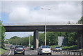
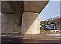
4

Cycleway Marker
National Cycle Network Route 72 Hadrian's Way. With the A1 road bridge crossing Scotswood Road.
Image: © wfmillar
Taken: 4 Jan 2010
0.10 miles
5
A1 road bridge crossing Scotswood Road (A6085)
On the north side of the River Tyne. The reinforced embankment on the right is just below a large B&Q store.
Image: © wfmillar
Taken: 4 Jan 2010
0.11 miles
6
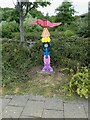
National Cycle Network milepost at Scotswood
This milepost stands on Hadrian's Cycleway in the shadow of Scotswood Bridge over the River Tyne. This milepost (of the so-called "Welsh" design) was repainted as part of the 2021 repainting program. It used to be green, see Image
Image: © Oliver Dixon
Taken: 3 Aug 2022
0.11 miles
7
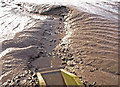
Culvert, River Tyne
Cutting through the mud on the north bank. Near Lemington Gut.
Image: © wfmillar
Taken: 4 Jan 2010
0.11 miles
8
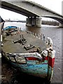
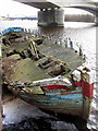
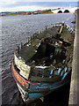
The Brekaer Wreck & Blaydon Bridge
The Scotswood railway and road bridges can be seen in the distance. Similar photos taken in 2003 Image and 2006 Image
Image: © Andrew Curtis
Taken: 8 Mar 2012
0.12 miles