IMAGES TAKEN NEAR TO
Harlow Hill, NEWCASTLE UPON TYNE, NE15 0QA
Introduction
This page details the photographs taken nearby to NE15 0QA by members of the Geograph project.
The Geograph project started in 2005 with the aim of publishing, organising and preserving representative images for every square kilometre of Great Britain, Ireland and the Isle of Man.

There are currently over 7.5m images from over14,400 individuals and you can help contribute to the project by visiting https://www.geograph.org.uk
Image Map
Images are licensed for reuse under creativecommons.org/licenses/by-sa/2.0
Notes
- Clicking on the map will re-center to the selected point.
- The higher the marker number, the further away the image location is from the centre of the postcode.
Image Listing (13 Images Found)
Images are licensed for reuse under creativecommons.org/licenses/by-sa/2.0
Image
Details
Distance
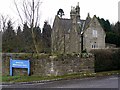
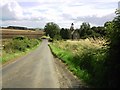
1
Whittle Dene House
The house acts as a lodge at the entrance to Whittle Dene Water Treatment Works. The road on the left runs between the Military Road from the hill top of Harlow Hill to the A69 west of Horsley and is known as Oatens Bank. There is another photo here Image
The Water Treatment Works is well hidden behind its screens of trees.
Image: © Andrew Curtis
Taken: 28 Jan 2012
0.00 miles
2
Whittle Dene House
House at the entrance to Whittle Dene Water Treatment Works.
Image: © Andrew Curtis
Taken: 10 Feb 2012
0.00 miles
3
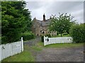
Whittle Dene House
Originally for workers of the water company. Not certain if it is now a private dwelling.
Image: © Les Hull
Taken: 28 Jun 2023
0.00 miles
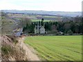
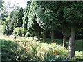
4
Water Works
This wonderful house fronts the water treatment works next to the Reservoir
Image: © Graham Scarborough
Taken: 28 Jul 2007
0.02 miles
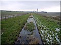
5
Hint of Water in Aqueduct leading from Whittle Dene Reservoirs
Image: © Les Hull
Taken: 28 Jun 2023
0.05 miles
6
Old Aqueduct
The abandoned aqueduct from the waterworks to Throckley taken from the bridge on Oatens Bank.
Image: © Janice Hind
Taken: 28 Aug 2008
0.05 miles
7
Aqueduct east of Whittle Dene Water Treatment Works
Formerly used to transport water from the Whittle Dene Reservoirs to Throckley by a system of aqueducts and tunnels. The track on the left provides access to Northside Farm.
Image: © Andrew Curtis
Taken: 10 Feb 2012
0.05 miles
8
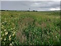
Aqueduct flowing from Whittle Dene Reservoirs
Not certain when water last flowed along this aqueduct. Must be water somewhere for the vegetation to be so luxuriant.
Image: © Les Hull
Taken: 28 Jun 2023
0.05 miles
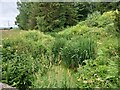
9
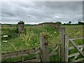
Footbridge over Aqueduct
I assume these were constructed to give farmer's access to their farmland.
Image: © Les Hull
Taken: 28 Jun 2023
0.13 miles