IMAGES TAKEN NEAR TO
Heddon-on-the-Wall, NEWCASTLE UPON TYNE, NE15 0HB
Introduction
This page details the photographs taken nearby to NE15 0HB by members of the Geograph project.
The Geograph project started in 2005 with the aim of publishing, organising and preserving representative images for every square kilometre of Great Britain, Ireland and the Isle of Man.

There are currently over 7.5m images from over14,400 individuals and you can help contribute to the project by visiting https://www.geograph.org.uk
Image Map
Images are licensed for reuse under creativecommons.org/licenses/by-sa/2.0
Notes
- Clicking on the map will re-center to the selected point.
- The higher the marker number, the further away the image location is from the centre of the postcode.
Image Listing (8 Images Found)
Images are licensed for reuse under creativecommons.org/licenses/by-sa/2.0
Image
Details
Distance
1
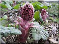
Butterbur (Petasites hybridus)
A large colony of butterbur is just coming into flower on the damp roadside of the narrow lane south of East Heddon.
Image: © Andrew Curtis
Taken: 20 Mar 2011
0.10 miles
2
Selman Park
A playing field, situated near the house of Denholme, provided by Heddon-on-the-Wall Parish Council chaired by the late Brian Selman. It is in regular use for matches and training by Heddon St Andrews Football Club, a junior club founded in 1996 http://www.clubwebsite.co.uk/heddonstandrewsfc01/
A club catering for seniors has recently formed and currently plays in North East Sunday League Division E http://www.webteams.co.uk/Home.aspx?team=heddonstandrewsseniors
Image: © Andrew Curtis
Taken: 28 Jan 2012
0.14 miles

4
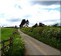
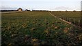
East Heddon
Looking up road to farm at top of hill, from South of farm
Image: © Newbiggin Hall Scouts
Taken: 30 Mar 2007
0.21 miles

6
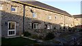
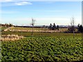
Converted farm buildings, East Heddon
The former byre and shelter sheds north of East Heddon are a Grade II Listed Building thought to have been a house originally, then shelter sheds and granary, now dwelling, dating to C16th or early C17th, extended and altered later.
List Entry Number: 1154814 https://www.historicengland.org.uk/listing/the-list/list-entry/1154814
Image: © Andrew Curtis
Taken: 22 Jan 2009
0.21 miles