IMAGES TAKEN NEAR TO
Terrace Place, NEWCASTLE UPON TYNE, NE1 4LS
Introduction
This page details the photographs taken nearby to Terrace Place, NE1 4LS by members of the Geograph project.
The Geograph project started in 2005 with the aim of publishing, organising and preserving representative images for every square kilometre of Great Britain, Ireland and the Isle of Man.

There are currently over 7.5m images from over14,400 individuals and you can help contribute to the project by visiting https://www.geograph.org.uk
Image Map
Images are licensed for reuse under creativecommons.org/licenses/by-sa/2.0
Notes
- Clicking on the map will re-center to the selected point.
- The higher the marker number, the further away the image location is from the centre of the postcode.
Image Listing (733 Images Found)
Images are licensed for reuse under creativecommons.org/licenses/by-sa/2.0
Image
Details
Distance
1
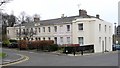
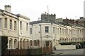
Leazes Crescent
An 1829 development by Thomas Oliver for Richard Grainger. Much less grand than their neighbouring scheme Image
Image: © Andrew Curtis
Taken: 18 Mar 2010
0.01 miles
2
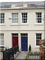
Leazes Crescent (detail)
The full south-west side of the terrace is shown here Image The terraced houses are of two storeys in pale render with an ornamental plaster (rinceau) frieze just below the roof-line.
Image: © Andrew Curtis
Taken: 18 Mar 2010
0.01 miles
3
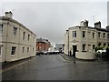
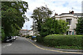
Top of Leazes Park Road
This road leads off Leazes Crescent here and runs south to Percy Street. These were middle class town houses built in the early Victorian period, on the outskirts of the city centre.
Image: © Robert Graham
Taken: 28 May 2019
0.02 miles
4
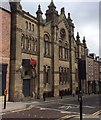
Former Synagogue, Leazes Park Road
the building was in use as a Synagogue until 1978
Image: © David Rogers
Taken: 29 Aug 2015
0.02 miles
6
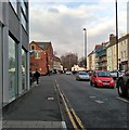
Leazes Park Road
In Newcastle city centre. This road runs north from Percy Street up to Leazes Park, as the name suggests. The trees in the park can be seen in this view looking north up the street from the junction with Strawberry Place. This is a busy traffic route as can be seen.
Image: © Robert Graham
Taken: 27 Nov 2018
0.03 miles
7
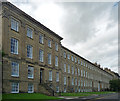
29-47 Leazes Terrace, Newcastle
The city's grandest Georgian set piece, and "as a single development [it] has no equal of that period in the north-eastern counties". It is in fact four terraces arranged around a roughly trapezoidal space (seen here is the east side), the north side deviating from perpendicularity, but there are commonalities such as height, emphasised ends and centres. By Thomas Oliver, 1829-34, for Richard Grainger. Grade I listed.
Much of it now houses some of the most lavishly accommodated students in the country (Newcastle University), though one hopes that students weren't allowed anywhere near any of the surviving interiors.
Image: © Stephen Richards
Taken: 16 Aug 2012
0.03 miles
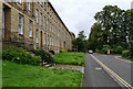
9
Leazes Crescent, NE1
Almost all the houses in the road are Grade II listed: https://www.historicengland.org.uk/listing/the-list/list-entry/1024830 , https://www.historicengland.org.uk/listing/the-list/list-entry/1087059 and https://www.historicengland.org.uk/listing/the-list/list-entry/1024831 .
Image: © Mike Quinn
Taken: 23 Feb 2018
0.03 miles
10
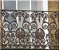
Detail of 58 Leazes Terrace, Newcastle
Close-up of the cast-iron balconies found throughout the terrace, these of a familiar type decorated with anthemia.
Full view: Image
Image: © Stephen Richards
Taken: 16 Aug 2012
0.04 miles